
Weißensee topographic map
Interactive map
Click on the map to display elevation.
About this map
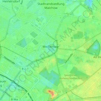
Name: Weißensee topographic map, elevation, terrain.
Location: Weißensee, Pankow, Berlin, Germany (52.53850 13.42906 52.56757 13.49568)
Average elevation: 54 m
Minimum elevation: 41 m
Maximum elevation: 74 m
Other topographic maps
Click on a map to view its topography, its elevation and its terrain.
Viktoriapark
On the occasion of the elevation of the monument ideas appeared to lay out a park around it. Two years later the design of a park was put out to tender. Hermann Mächtig (*1837-1909*), since 1877 Berlin's city garden director, handed in a design, already using the name Victoria Park, in honour of Princess…
Average elevation: 45 m