Geolocate

West Tripura topographic map

Interactive map

Click on the map to display elevation.

About this map

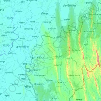
Name: West Tripura topographic map, elevation, terrain.

Location: West Tripura, Tripura, India (23.21667 90.80000 24.61667 92.20000)

Average elevation: 50 m

Minimum elevation: -2 m

Maximum elevation: 830 m

Other topographic maps

Click on a map to view its topography, its elevation and its terrain.

Amarpur

India > Tripura

Average elevation: 96 m

Gomati

India > Tripura

Topographically, the Gomati district is marked by lush green and fertile Gomati valleys. The towering Debtamura hill range which straddles Udaipur and Amarpur subdivisions of the district with its exquisite sculptural works carved on panels of the hills.

Average elevation: 67 m

Unakoti

India > Tripura > Panisagar

Average elevation: 112 m

Khowai

India > Tripura

Average elevation: 40 m

Sepahijala

India > Tripura

Average elevation: 29 m

Ganganagar

India > Tripura

Average elevation: 141 m

Hrishyamukh

India > Tripura

Average elevation: 33 m

Dumboor Lake

India > Tripura > Raishyabari > Raishyabari

Average elevation: 108 m

Teliamura

India > Tripura

Average elevation: 88 m

Dhalai

India > Tripura

The climate in Setrai, which is about 40 km from Ambassa, displays characteristics that are typical of the hilly and mountainous region. The change in the topographical features, heavy rainfall and altitude of the region causes a change in the climatic conditions in Setrai. The climate and other factors of the…

Average elevation: 138 m

North Tripura

India > Tripura

Average elevation: 165 m

Mandai

India > Tripura

Average elevation: 64 m

Gumti WLS

India > Tripura > Ganganagar

Average elevation: 109 m

Salema

India > Tripura > Salema

Average elevation: 113 m