
Namib-Naukluft National Park topographic map
Interactive map
Click on the map to display elevation.
About this map
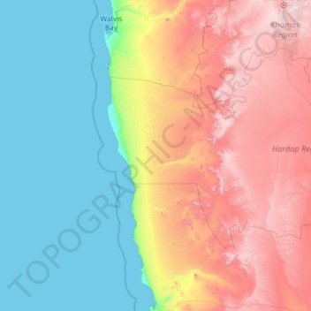
Name: Namib-Naukluft National Park topographic map, elevation, terrain.
Location: Namib-Naukluft National Park, Hardap, Namibia (-26.70751 14.43302 -22.51202 16.42338)
Average elevation: 631 m
Minimum elevation: 0 m
Maximum elevation: 2,336 m
Other topographic maps
Click on a map to view its topography, its elevation and its terrain.
Rehoboth
Rehoboth is a town in central Namibia just north of the Tropic of Capricorn. Located 90 kilometres (55 miles) south of the Namibian capital Windhoek, Rehoboth lies on a high elevation plateau with several natural hot-water springs. It receives sparse mean annual rainfall of 240 millimetres (9.4 in), although…
Average elevation: 1,408 m