
Kampung Janda Baik topographic map
Interactive map
Click on the map to display elevation.
Kampung Janda Baik
Before Janda Baik was founded in 1930, the area was primarily inhabited by Orang Asli tribes. The village was founded when some residents moved from Bentong to an area with a higher elevation due to the 1926 floods that affected Bentong and other low elevation areas. The earliest founders for this village are Haji Deris, Haji Kadir, and Haji Yasir, who built a hut and stayed in the area for almost a week before others start to populate the area. The village was originally given the name Kampung Tiga Haji to refer to the three early settlers.
About this map
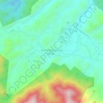
Name: Kampung Janda Baik topographic map, elevation, terrain.
Location: Kampung Janda Baik, Bentong, Pahang, 28750, Malaysia (3.31174 101.83763 3.35174 101.87763)
Average elevation: 467 m
Minimum elevation: 288 m
Maximum elevation: 816 m
Other topographic maps
Click on a map to view its topography, its elevation and its terrain.
Padang SMK Jengka Pusat
Malaysia > Pahang > Bandar Tun Abdul Razak (Bandar Jengka)
Average elevation: 75 m
Sungai Ruan
Covering a total area of 9.7 square km at an average elevation of 227 meters above sea level, the village is surrounded by hills, forest and plantations with a population of about 6,000 people.
Average elevation: 142 m
Tioman Island
Local mythology claims that the island is the embodiment of the mighty dragon Sri Gumom. The dragon was on his way to visit his sister Gunung Linga (Lingin Peak). Still, the great Sri Rama forbade the meeting, and Sri Gumom was turned into a stone and fell into the deep sea where he now remains, frozen in…
Average elevation: 104 m
Cameron Highlands
Surveyed by the government geologist and explorer William Cameron in 1885, the outpost consists of three mukims (subdistricts), namely Ringlet, Tanah Rata and Ulu Telom. Its eight settlements are Ringlet, Tanah Rata (the administrative centre), Brinchang, the Bertam Valley, Kea Farm, Tringkap, Kampung Kuala…
Average elevation: 1,117 m
Malaysia National Park
Taman Negara features a largely virgin, lowland dipterocarp rainforest as well as Peninsular Malaysian montane rain forests on the higher elevation parts of the park.
Average elevation: 320 m