
Sturgeon Bay topographic map
Interactive map
Click on the map to display elevation.
Sturgeon Bay
Stevens Hill is a populated place within the city of Sturgeon Bay, just to the northeast of the downtown. The top of the hill has the highest elevation in the city. It is within Big Hill Park, which is 13.2 acres in area and is used for mountain biking, picnicking, and sledding.
About this map
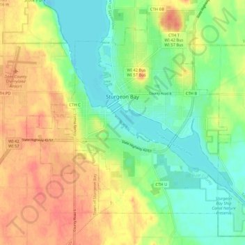
Name: Sturgeon Bay topographic map, elevation, terrain.
Location: Sturgeon Bay, Door County, Wisconsin, 54235, United States (44.79181 -87.41787 44.86064 -87.31366)
Average elevation: 199 m
Minimum elevation: 173 m
Maximum elevation: 229 m
Other topographic maps
Click on a map to view its topography, its elevation and its terrain.