
Chitral topographic map
Interactive map
Click on the map to display elevation.
About this map
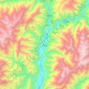
Name: Chitral topographic map, elevation, terrain.
Average elevation: 2,982 m
Minimum elevation: 1,358 m
Maximum elevation: 5,126 m
The city has an average elevation of 1,500 m (4,921 ft).
Other topographic maps
Click on a map to view its topography, its elevation and its terrain.
Mastuj Tehsil
Pakistan > Khyber Pakhtunkhwa > Chitrāl District
Mastuj Tehsil, Upper Chitral District, Chitrāl District, Malakand Division, Khyber Pakhtunkhwa, Pakistan
Average elevation: 4,143 m
Buni Zom
Pakistan > Khyber Pakhtunkhwa > Chitrāl District > Mastuj Tehsil
Buni Zom, Mastuj Tehsil, Upper Chitral District, Chitrāl District, Malakand Division, Khyber Pakhtunkhwa, Pakistan
Average elevation: 5,757 m
Drosh Tehsil
Pakistan > Khyber Pakhtunkhwa > Chitrāl District
Drosh Tehsil, Lower Chitral District, Chitrāl District, Malakand Division, Khyber Pakhtunkhwa, 17220, Pakistan
Average elevation: 3,012 m
Koyo Zom
Pakistan > Khyber Pakhtunkhwa > Chitrāl District
Koyo Zom, Upper Chitral District, Chitrāl District, Malakand Division, Khyber Pakhtunkhwa, Pakistan
Average elevation: 5,925 m
Gree
Pakistan > Khyber Pakhtunkhwa > Chitrāl District > Chitral Tehsil
Gree, Chitral Tehsil, Lower Chitral District, Chitrāl District, Malakand Division, Khyber Pakhtunkhwa, Pakistan
Average elevation: 2,883 m
Hindu Kush
Pakistan > Khyber Pakhtunkhwa > Chitrāl District > Chitral Tehsil
Hindu Kush, Chitral Tehsil, Lower Chitral District, Chitrāl District, Malakand Division, Khyber Pakhtunkhwa, Pakistan
Average elevation: 5,281 m