
Bures topographic map
Interactive map
Click on the map to display elevation.
About this map
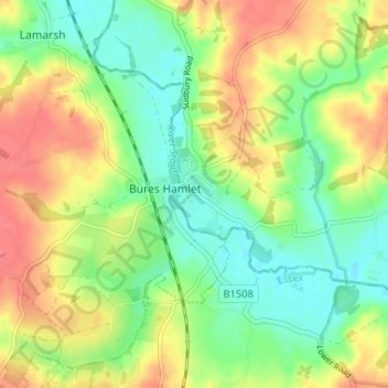
Name: Bures topographic map, elevation, terrain.
Location: Bures, Babergh, Suffolk, England, CO8 5EF, United Kingdom (51.95115 0.75635 51.99115 0.79635)
Average elevation: 42 m
Minimum elevation: 14 m
Maximum elevation: 75 m
Suffolk trails, hiking, mountain biking, running and outdoor activities
Other topographic maps
Click on a map to view its topography, its elevation and its terrain.
Long Melford-Bury St Edmunds branch line
United Kingdom > England > Suffolk > Babergh > Lavenham
Average elevation: 70 m