
Make a donation
Gear up for your next adventure:
As an Amazon Associate, this site earns from qualifying purchases at no extra cost to you.
Mount Lebanon Governorate topographic map
Click on the map to display elevation.
Gear up for your next adventure:
As an Amazon Associate, this site earns from qualifying purchases at no extra cost to you.
Mount Lebanon Governorate
The governorate's altitude ranges from zero to 3,000 meters above sea level. It has diverse geographical features, including urban areas, mixed rural areas and natural areas. It is crossed by 5 rivers (Nahr El Kalb, Nahr Beirut, Damour, Awali River and Nahr Ibrahim) and includes the Shabrouh Dam with a capacity of 8 million cubic meters of water.
Make a donation
Gear up for your next adventure:
As an Amazon Associate, this site earns from qualifying purchases at no extra cost to you.
About this map
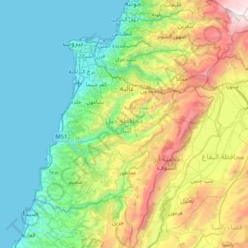
Name: Mount Lebanon Governorate topographic map, elevation, terrain.
Location: Mount Lebanon Governorate, Lebanon (33.49363 35.38596 33.98039 35.89978)
Average elevation: 670 m
Minimum elevation: -1 m
Maximum elevation: 2,612 m
Make a donation
Gear up for your next adventure:
As an Amazon Associate, this site earns from qualifying purchases at no extra cost to you.
Other topographic maps
Click on a map to view its topography, its elevation and its terrain.
Laqlouq
Lebanon > Keserwan-Jbeil Governorate
Laqlouq (Arabic: لقلوق), also spelled Laklouk and also known as ′Arab Laqlouq (Arabic: عرب القلوق) is a small mountainous village in mountainous area in the Byblos District of Keserwan-Jbeil Governorate, Lebanon. It is located 69 kilometers northeast of Beirut. Laqlouq has an average elevation…
Average elevation: 1,746 m
Make a donation
Gear up for your next adventure:
As an Amazon Associate, this site earns from qualifying purchases at no extra cost to you.
Make a donation
Gear up for your next adventure:
As an Amazon Associate, this site earns from qualifying purchases at no extra cost to you.
Beshamoun
Lebanon > Mount Lebanon Governorate
Bechamoun (Arabic: بشامون), is a town near Beirut in the Mount Lebanon Governorate of Lebanon. It has an area about 6.6 square kilometres and elevation between 60 and 580 metres above sea level. It lies 8 kilometres from Beirut’s airport and central Beirut. The town has a population of greater than 80000.
Average elevation: 402 m
Make a donation
Gear up for your next adventure:
As an Amazon Associate, this site earns from qualifying purchases at no extra cost to you.
Mount Lebanon
Mount Lebanon is a mountain range in Lebanon. It is about 170 km (110 mi) long and averages above 2,500 m (8,200 ft) in elevation, with its peak at 3,088 m (10,131 ft). The range provides a typical alpine climate year-round.
Average elevation: 2,819 m
Qaraoun
The development activity near the village, consequent to land area the Qaraoun village transferred for building of the El Qaraoun Dam in the middle reaches of the Litani River, which created an artificial lake (33°34′11.63″N 35°41′51.18″E / 33.5698972°N 35.6975500°E / 33.5698972;…
Average elevation: 1,027 m
Baadaran
Lebanon > Mount Lebanon Governorate
Baadarâne (Arabic: بعدران Baʿdarān), is an area in Chouf, Mont Liban, Lebanon. Baadarane is 60 kilometres (37 mi) away from Beirut at an elevation of 1,050 meters .
Average elevation: 920 m
Zahle
Zahlé is located 55 km (34 mi) east of the capital Beirut, close to the Beirut-Damascus road, and lies at the junction of Mount Lebanon and the Beqaa Valley, at a mean elevation of 1,000 m. Established in the 18th century by Christians, Zahlé maintains its predominantly Greek Catholic character. The city has…
Average elevation: 1,281 m
Make a donation
Gear up for your next adventure:
As an Amazon Associate, this site earns from qualifying purchases at no extra cost to you.
Baabdat
Lebanon > Mount Lebanon Governorate
Baabdat (Arabic: بعبدات) is a town located in the Matn District of Mount Lebanon, 22 km from Beirut at an altitude ranging between 600 and 1100 meters above sea level. The lush pine forests that surround the town make it a very popular summer resort for those escaping the busy coastal cities of Lebanon,…
Average elevation: 740 m
Make a donation
Gear up for your next adventure:
As an Amazon Associate, this site earns from qualifying purchases at no extra cost to you.
Faraya
Lebanon > Keserwan-Jbeil Governorate
Faraya (Arabic: فاريا) is a village and municipality in the Keserwan District of the Keserwan-Jbeil Governorate, Lebanon. It is located 46 kilometers north of Beirut. Elevation start from 1290 meters to 2000 meters above sea level and its total land area is 870 hectares. Faraya's inhabitants are…
Average elevation: 1,558 m
Lassa
Lebanon > Keserwan-Jbeil Governorate
Lassa (Arabic: لاسا) is a municipality in the Byblos District of Keserwan-Jbeil Governorate, Lebanon. It is 90 kilometers north of Beirut. Lassa has an average elevation of 1,130 meters above sea level and a total land area of 739 hectares. The village contains one public school, which enrolled 15 students…
Average elevation: 1,315 m
Make a donation
Gear up for your next adventure:
As an Amazon Associate, this site earns from qualifying purchases at no extra cost to you.
Make a donation
Gear up for your next adventure:
As an Amazon Associate, this site earns from qualifying purchases at no extra cost to you.
Make a donation
Gear up for your next adventure:
As an Amazon Associate, this site earns from qualifying purchases at no extra cost to you.
Ain Dara
Lebanon > Mount Lebanon Governorate
Ain Dara is located on a southward facing slope overlooking the pine forests of the Safa valley with an average altitude of 1,250 metres (4,100 ft) above sea level. It is close to Mount Barouk, which is famous for its cedar forest. Its altitude gives it cool summers and cold winters with heavy snowfall.
Average elevation: 1,319 m
Hazmieh
Lebanon > Mount Lebanon Governorate
Hazmieh covers an area of 2.73 square kilometers directly southeast of Beirut, at an elevation of between 50–200 meters above sea level. Its borders are defined by the Beirut River and Sin El Fil Boulevard to the north, Camille Chamoun Boulevard to the west, by El Sayad Roundabout and Rihaniyya Junction to…
Average elevation: 118 m
Make a donation
Gear up for your next adventure:
As an Amazon Associate, this site earns from qualifying purchases at no extra cost to you.
Ashqout
Lebanon > Keserwan-Jbeil Governorate
Ashqout (Arabic: عشقوت; also spelled Ashkout, Achqout, `Ashqut) is a town and municipality in the Keserwan District of the Keserwan-Jbeil Governorate of Lebanon. It is located 31 kilometers north of Beirut. Ashqout's average elevation is 1,000 meters above sea level and its total land area is 588…
Average elevation: 1,039 m
Make a donation
Gear up for your next adventure:
As an Amazon Associate, this site earns from qualifying purchases at no extra cost to you.
Deir Al Qamar
Lebanon > Mount Lebanon Governorate
Deir al-Qamar (Arabic: دَيْر الْقَمَر, romanized: Dayr al-qamar, lit. 'Monastery of the moon') is a city south-east of Beirut in south-central Lebanon. It is located five kilometres outside of Beit ed-Dine in the Chouf District of the Mount Lebanon Governorate at 800 m of average altitude.
Average elevation: 749 m
Make a donation
Gear up for your next adventure:
As an Amazon Associate, this site earns from qualifying purchases at no extra cost to you.
Jaj
Lebanon > Keserwan-Jbeil Governorate
Jaj (Arabic: جاج, also spelled Jaje) is a mountainous village in the Byblos District of Keserwan-Jbeil Governorate, Lebanon. It is 68 kilometers north of Beirut. Jaj has an average elevation of 1,220 meters above sea level and a total land area of 1,174 hectares. Its inhabitants are predominantly Maronite…
Average elevation: 1,266 m
Make a donation
Gear up for your next adventure:
As an Amazon Associate, this site earns from qualifying purchases at no extra cost to you.
Bsharri
Bsharri (Arabic: بشرّي Bšarrī; also romanized Becharre, Bcharre, Bsharre, Bcharre Al Arz) is a Lebanese town located in the district of the same name, North Governorate, situated at altitudes between 1,100 m (3,600 ft) and 3,088 m (10,131 ft). Bsharri is the location of the Cedars of God, a UNESCO World…
Average elevation: 1,847 m
Jaj
Lebanon > Keserwan-Jbeil Governorate
Jaj (Arabic: جاج, also spelled Jaje) is a mountainous village in the Byblos District of Keserwan-Jbeil Governorate, Lebanon. It is 68 kilometers north of Beirut. Jaj has an average elevation of 1,220 meters above sea level and a total land area of 1,174 hectares. Its inhabitants are predominantly Maronite…
Average elevation: 1,266 m
Make a donation
Gear up for your next adventure:
As an Amazon Associate, this site earns from qualifying purchases at no extra cost to you.
Sawfar
Lebanon > Mount Lebanon Governorate
Ru’ Aysat Sawfar or Sawfar (Arabic: رويسات صوفر or صوفر, French: Rue’ Aysat Sawfar), Sawfar, Saoufar or Sofar) is a village in the Aley District of the Mount Lebanon Governorate in Lebanon. Perched at an elevation of more than 1,433 metres (4,701 feet), Sawfar lies adjacent to the main road…
Average elevation: 1,157 m
Make a donation
Gear up for your next adventure:
As an Amazon Associate, this site earns from qualifying purchases at no extra cost to you.
Yanta
The village sits about 1,540 metres (5,050 ft) above sea level. The name is variously claimed to mean "God sows" or "God the sower" in Semitic, "white dove" in Syriac and "elevation" in Arabic. It has been noted that a special type of yellow marl (lake sediments) has been noticed in Yanta and the surrounding…
Average elevation: 1,450 m
Kousba
Kousba's surface is 6.02 square kilometers, with an altitude of 500 meters.
Average elevation: 455 m
Make a donation
Gear up for your next adventure:
As an Amazon Associate, this site earns from qualifying purchases at no extra cost to you.
Zahle
Zahlé is located 55 km (34 mi) east of the capital Beirut, close to the Beirut-Damascus road, and lies at the junction of Mount Lebanon and the Beqaa Valley, at a mean elevation of 1,000 m. Established in the 18th century by Christians, Zahlé maintains its predominantly Greek Catholic character. The city has…
Average elevation: 1,281 m
Make a donation
Gear up for your next adventure:
As an Amazon Associate, this site earns from qualifying purchases at no extra cost to you.
Make a donation
Gear up for your next adventure:
As an Amazon Associate, this site earns from qualifying purchases at no extra cost to you.
Make a donation
Gear up for your next adventure:
As an Amazon Associate, this site earns from qualifying purchases at no extra cost to you.
Make a donation
Gear up for your next adventure:
As an Amazon Associate, this site earns from qualifying purchases at no extra cost to you.
Make a donation
Gear up for your next adventure:
As an Amazon Associate, this site earns from qualifying purchases at no extra cost to you.