
Sömmerda topographic map
Interactive map
Click on the map to display elevation.
About this map
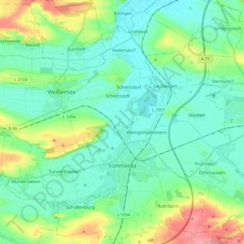
Name: Sömmerda topographic map, elevation, terrain.
Location: Sömmerda, Landkreis Sömmerda, Thuringia, 99610, Germany (51.12171 11.04143 51.24618 11.23796)
Average elevation: 155 m
Minimum elevation: 128 m
Maximum elevation: 237 m
Other topographic maps
Click on a map to view its topography, its elevation and its terrain.
Rudersdorf
Germany > Thuringia > Landkreis Sömmerda
Rudersdorf, Buttstädt, Landkreis Sömmerda, Thuringia, Germany
Average elevation: 206 m
Büchel
Germany > Thuringia > Landkreis Sömmerda
Büchel, Kindelbrück, Landkreis Sömmerda, Thuringia, Germany
Average elevation: 139 m
Bilzingsleben
Germany > Thuringia > Landkreis Sömmerda > Kindelbrück
Bilzingsleben, Kindelbrück, Landkreis Sömmerda, Thuringia, 06578, Germany
Average elevation: 228 m