
Make a donation
Gear up for your next adventure:
As an Amazon Associate, this site earns from qualifying purchases at no extra cost to you.
Wallis topographic map
Click on the map to display elevation.
Gear up for your next adventure:
As an Amazon Associate, this site earns from qualifying purchases at no extra cost to you.
Wallis
Valais is the highest canton in terms of absolute, relative, and mean elevation. Therefore, its topography is extremely rugged, with the notable exception of the wide, glacial, Rhône valley. The latter valley dominates the geography of the canton. Many side valleys are branching off the main valley, often perpendicularly. These vary from narrow and remote to reasonably populous. On the south side of the Rhône, in the Valais Alps, some of the largest side valleys are (from east to west): the Mattertal (including the Saastal), the Val d'Anniviers, the Val d'Hérens, the Val de Bagnes and the Val d'Entremont. On the north of the Rhône, in the Bernese Alps, the Lötschental is the only large valley. East of Brig is the valley of Goms, the highest section of the Rhône Valley. The Rhône itself flows in the main valley from east to west from the Rhône Glacier down to Martigny, then at a right angle north to its mouth in Lake Geneva. After the town of Saint-Maurice, the eastern banks of the river belong to the canton of Vaud, although the western banks remain in Valais, down to Le Bouveret, on the shores of Lake Geneva. The main valley is bounded by the Bernese Alps in the north and the Valais Alps in the south, both ranges including numerous over 4,000 metre-high mountains, which are the highest in the country. Notables mountains include Monte Rosa (highest), reaching 4,634 metres (15,203 ft), and the Finsteraarhorn (most prominent), reaching 4,274 metres (14,022 ft). Other iconic mountains are the Matterhorn and the Jungfrau, for a complete list, see list of mountains of Valais. Located there are numerous glaciers including several of the largest in the Alps, such as the Aletsch Glacier and the Gorner Glacier. Other ranges situated partially in Valais are the Chablais Alps, the Mont Blanc Massif, the Uri Alps, the Gotthard Massif, and the Lepontine Alps.
Make a donation
Gear up for your next adventure:
As an Amazon Associate, this site earns from qualifying purchases at no extra cost to you.
About this map
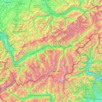
Name: Wallis topographic map, elevation, terrain.
Location: Wallis, Switzerland (45.85831 6.77063 46.65405 8.47856)
Average elevation: 1,728 m
Minimum elevation: 190 m
Maximum elevation: 4,728 m
Make a donation
Gear up for your next adventure:
As an Amazon Associate, this site earns from qualifying purchases at no extra cost to you.
Other topographic maps
Click on a map to view its topography, its elevation and its terrain.
Make a donation
Gear up for your next adventure:
As an Amazon Associate, this site earns from qualifying purchases at no extra cost to you.
Furi
Switzerland > Wallis > Visp > Zermatt
Furi is an alpine hamlet in the Pennine Alps, located three kilometers south of Zermatt, Switzerland at an altitude of 1,687m. It is located on a relatively flat area of land between the Gornera and Zmuttbach rivers.
Average elevation: 2,206 m
Make a donation
Gear up for your next adventure:
As an Amazon Associate, this site earns from qualifying purchases at no extra cost to you.
Make a donation
Gear up for your next adventure:
As an Amazon Associate, this site earns from qualifying purchases at no extra cost to you.
Männlichen
Switzerland > Bern > Interlaken-Oberhasli administrative district > Grindelwald
Average elevation: 1,709 m
Make a donation
Gear up for your next adventure:
As an Amazon Associate, this site earns from qualifying purchases at no extra cost to you.
Hockenhorn
Switzerland > Bern > Frutigen-Niedersimmental administrative district > Kandersteg
Average elevation: 2,599 m
Make a donation
Gear up for your next adventure:
As an Amazon Associate, this site earns from qualifying purchases at no extra cost to you.
Hockenhorn
Switzerland > Bern > Frutigen-Niedersimmental administrative district > Kandersteg
Average elevation: 2,599 m
Eau-Rouge
Switzerland > Wallis > Entremont > Chamoille (Sembrancher) > Les Champmanins
Average elevation: 1,034 m
Make a donation
Gear up for your next adventure:
As an Amazon Associate, this site earns from qualifying purchases at no extra cost to you.
Make a donation
Gear up for your next adventure:
As an Amazon Associate, this site earns from qualifying purchases at no extra cost to you.
Eiger
Switzerland > Bern > Interlaken-Oberhasli administrative district > Grindelwald
Average elevation: 2,944 m
Make a donation
Gear up for your next adventure:
As an Amazon Associate, this site earns from qualifying purchases at no extra cost to you.
Make a donation
Gear up for your next adventure:
As an Amazon Associate, this site earns from qualifying purchases at no extra cost to you.
Haldenstein
Switzerland > Grisons > Plessur > Chur
Before 2017, the municipality was located in the Fünf Dörfer sub-district of the Landquart district, after 2017 it was part of the Plessur Region. It is located north of Chur and on the left bank of the Rhine River. It consists of the haufendorf (an irregular, unplanned and quite closely packed village,…
Average elevation: 826 m
Make a donation
Gear up for your next adventure:
As an Amazon Associate, this site earns from qualifying purchases at no extra cost to you.
Make a donation
Gear up for your next adventure:
As an Amazon Associate, this site earns from qualifying purchases at no extra cost to you.
Les Briesses
Switzerland > Wallis > Sierre > Crans-Montana > Chermignon-d'en-Bas
Average elevation: 1,179 m
Horeweid
Switzerland > Bern > Interlaken-Oberhasli administrative district > Därligen
Average elevation: 1,162 m
Make a donation
Gear up for your next adventure:
As an Amazon Associate, this site earns from qualifying purchases at no extra cost to you.
Make a donation
Gear up for your next adventure:
As an Amazon Associate, this site earns from qualifying purchases at no extra cost to you.
Dents du Midi
Switzerland > Wallis > Monthey > Val-d'Illiez
The Dents du Midi are situated on the border between the communes of Val-d'Illiez and Evionnaz. The north face rises above the Val d'Illiez while the south face overlooks the Lac de Salanfe, an artificial reservoir. The ridge of the chain is situated at an altitude varying between 2,997 and 3,258 meters (9,833…
Average elevation: 2,440 m
Make a donation
Gear up for your next adventure:
As an Amazon Associate, this site earns from qualifying purchases at no extra cost to you.
Make a donation
Gear up for your next adventure:
As an Amazon Associate, this site earns from qualifying purchases at no extra cost to you.
Chironico
Switzerland > Ticino > Distretto di Leventina
The municipality is located in the Leventina district, on the right slope of the mid-Leventina valley at an elevation of 786 meters (2,579 ft). The municipality stretches from the Ticino river at the Biaschina-Schlucht (elevation 450 m (1,480 ft)) up to the Pizzo Campo Tencia (3,072 m (10,079 ft)) in the upper…
Average elevation: 1,026 m
Make a donation
Gear up for your next adventure:
As an Amazon Associate, this site earns from qualifying purchases at no extra cost to you.
Make a donation
Gear up for your next adventure:
As an Amazon Associate, this site earns from qualifying purchases at no extra cost to you.
Mase
Switzerland > Wallis > Hérens > Mont-Noble
The village is located in the Hérens district on the right bank of the Borgne and the left bank of the Rhone in the Val d'Hérens at an elevation of 1,345 m (4,413 ft). It consists of the village of Mase.
Average elevation: 1,272 m
Make a donation
Gear up for your next adventure:
As an Amazon Associate, this site earns from qualifying purchases at no extra cost to you.
Lac Vert
Switzerland > Wallis > Monthey > Val-d'Illiez
Lake Vert is a lake in the Chablais region of the canton of Valais, Switzerland. The lake is located in the municipality of Val-d'Illiez, at an elevation of 1972 metres, near the border with France. Lac de Chésery lies 600 metres north.
Average elevation: 1,932 m
Make a donation
Gear up for your next adventure:
As an Amazon Associate, this site earns from qualifying purchases at no extra cost to you.
Make a donation
Gear up for your next adventure:
As an Amazon Associate, this site earns from qualifying purchases at no extra cost to you.
Lac Vert
Switzerland > Wallis > Monthey > Val-d'Illiez
Lake Vert is a lake in the Chablais region of the canton of Valais, Switzerland. The lake is located in the municipality of Val-d'Illiez, at an elevation of 1972 metres, near the border with France. Lac de Chésery lies 600 metres north.
Average elevation: 1,932 m
Make a donation
Gear up for your next adventure:
As an Amazon Associate, this site earns from qualifying purchases at no extra cost to you.
Hasliberg Wasserwendi
Switzerland > Bern > Interlaken-Oberhasli administrative district
Average elevation: 1,247 m
Make a donation
Gear up for your next adventure:
As an Amazon Associate, this site earns from qualifying purchases at no extra cost to you.
Make a donation
Gear up for your next adventure:
As an Amazon Associate, this site earns from qualifying purchases at no extra cost to you.
Make a donation
Gear up for your next adventure:
As an Amazon Associate, this site earns from qualifying purchases at no extra cost to you.
Make a donation
Gear up for your next adventure:
As an Amazon Associate, this site earns from qualifying purchases at no extra cost to you.