Geolocate

Rajmahal topographic map

Interactive map

Click on the map to display elevation.

About this map

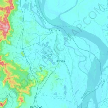
Name: Rajmahal topographic map, elevation, terrain.

Location: Rajmahal, Sahibganj, Jharkhand, 816108, India (24.85478 87.71665 25.12905 87.96392)

Average elevation: 46 m

Minimum elevation: 19 m

Maximum elevation: 361 m

Other topographic maps

Click on a map to view its topography, its elevation and its terrain.

Alampur

India > Jharkhand > Rajmahal

Alampur, Rajmahal, Sahibganj District, Jharkhand, India

Average elevation: 29 m

Dharampur

India > Jharkhand > Rajmahal

Dharampur, Rajmahal, Sahibganj District, Jharkhand, India

Average elevation: 28 m

Dogachhi

India > Jharkhand > Rajmahal > Stridhas

Dogachhi, unsurveyed, Stridhas, Rajmahal, Sahibganj (district), Jharkhand, India

Average elevation: 24 m

Manikpur

India > Jharkhand > Rajmahal

Manikpur, Rajmahal, Sahibganj (district), Jharkhand, India

Average elevation: 32 m