
Woodberry topographic map
Interactive map
Click on the map to display elevation.
About this map
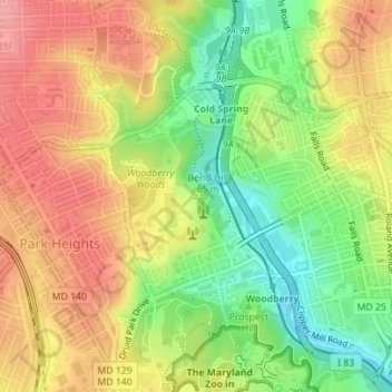
Name: Woodberry topographic map, elevation, terrain.
Location: Woodberry, Baltimore, Maryland, United States (39.32956 -76.65823 39.34524 -76.64207)
Average elevation: 94 m
Minimum elevation: 40 m
Maximum elevation: 141 m
Other topographic maps
Click on a map to view its topography, its elevation and its terrain.
Baltimore
United States > Maryland > Baltimore
Baltimore, Maryland, 21233, United States
Average elevation: 65 m
Middle East
United States > Maryland > Baltimore
Middle East, Baltimore, Maryland, United States
Average elevation: 29 m
Cedarcroft
United States > Maryland > Baltimore
Cedarcroft, Baltimore, Maryland, United States
Average elevation: 126 m
Broadway East
United States > Maryland > Baltimore
Broadway East, Baltimore, Maryland, United States
Average elevation: 36 m
Saint Josephs
United States > Maryland > Baltimore
Saint Josephs, Baltimore, Maryland, United States
Average elevation: 49 m
Frankford
United States > Maryland > Baltimore
Frankford, Baltimore, Maryland, 21206, United States
Average elevation: 40 m