
Şirinevler Mahallesi topographic map
Interactive map
Click on the map to display elevation.
About this map
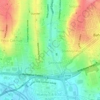
Name: Şirinevler Mahallesi topographic map, elevation, terrain.
Average elevation: 38 m
Minimum elevation: 3 m
Maximum elevation: 90 m
Other topographic maps
Click on a map to view its topography, its elevation and its terrain.
Yenibosna Merkez Mahallesi
Yenibosna Merkez Mahallesi, Bahçelievler, Istanbul, Marmara Region, 34197, Turkey
Average elevation: 43 m