Geolocate

Mljet topographic map

Interactive map

Click on the map to display elevation.

About this map

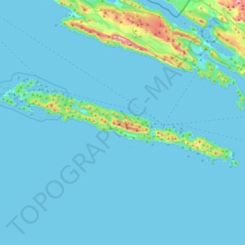
Name: Mljet topographic map, elevation, terrain.

Location: Mljet, Dubrovnik-Neretva County, Croatia (42.68663 17.31716 42.80533 17.75418)

Average elevation: 45 m

Minimum elevation: -2 m

Maximum elevation: 622 m

Other topographic maps

Click on a map to view its topography, its elevation and its terrain.

Bosanka

Croatia > Dubrovnik-Neretva County > Dubrovnik

Average elevation: 156 m

Nuga

Croatia > Dubrovnik-Neretva County > Borovci

Average elevation: 173 m

Prižba

Croatia > Dubrovnik-Neretva County

Average elevation: 88 m

Klek

Croatia > Dubrovnik-Neretva County

Average elevation: 131 m

Šibenik

Croatia > Dubrovnik-Neretva County > Duba

Average elevation: 88 m

Čilipi

Croatia > Dubrovnik-Neretva County > Čilipi

Average elevation: 109 m