
Qinghai topographic map
Interactive map
Click on the map to display elevation.
Qinghai
By area, Qinghai is the largest province in the People's Republic of China (excluding the autonomous regions). Qinghai Lake is the largest salt water lake in China, and the second largest in the world. The Qaidam basin lies in the northwest part of the province. About a third of this resource rich basin is desert. The basin has an altitude between 3000 and 3500 meters.
About this map
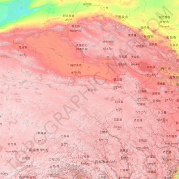
Name: Qinghai topographic map, elevation, terrain.
Location: Qinghai, China (31.60180 89.40222 39.21423 103.06941)
Average elevation: 3,710 m
Minimum elevation: 787 m
Maximum elevation: 6,545 m
Other topographic maps
Click on a map to view its topography, its elevation and its terrain.
Chongqing
The central urban area of Chongqing, or Chongqing proper, is a city of unique features. Built on mountains and partially surrounded by the Yangtze and Jialing rivers, it is known as a "mountain city" and a "city on rivers". The night scene of the city is very illuminated, with millions of lights and their…
Average elevation: 318 m
Hemu River
China > Xinjiang > Burqin County > Kom-Kanas Mongolian Ethnic Township
Average elevation: 1,732 m
Gasherbrum II
China > Xinjiang > Taxkorgan Tajik Autonomous County > Dafdar
Gasherbrum II is located on the border of Gilgit–Baltistan, Pakistan, and Xinjiang, China. It is part of the Karakoram mountain range in the Himalayas, and located at the top of the Baltoro Glacier. With an elevation of 8,034 metres (26,358 ft) it is the third-highest member of the Gasherbrum group, behind…
Average elevation: 7,098 m
Mount Wudang
China > Hubei > Danjiangkou City
Modern maps show the elevation of the highest of the peaks in the Wudang Shan "proper" as 1612 meters; however, the entire Wudangshan range has somewhat higher elevations elsewhere.
Average elevation: 1,172 m
Kawagarbo
China > Tibet > Chamdo City
The Kawa Karpo has over 20 peaks with permanent snow cover, including six peaks over 6,000 m (19,700 ft). Topographic extremes are immense, with vertical relief ranging from less than 2,000 m along the Mekong River on the east to 6,740 m on the summit of Kawa Karpo within 10 km horizontal distance. Even…
Average elevation: 5,809 m
Napahai Nature Reserve
China > Yunnan > Shangri-La > Jiantang > Chui Zongdala
Average elevation: 3,410 m
Yarkand
China > Xinjiang > Yarkant County
Yarkant County, also Shache County, also transliterated from Uyghur as Yakan County, is a county in the Xinjiang Uyghur Autonomous Region, China, located on the southern rim of the Taklamakan Desert in the Tarim Basin. It is one of 11 counties administered under Kashgar Prefecture. The county, usually referred…
Average elevation: 1,227 m