
Binh Phuoc Province topographic map
Interactive map
Click on the map to display elevation.
About this map
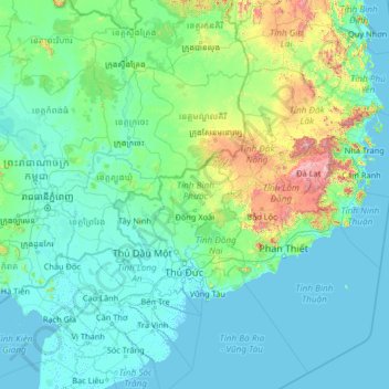
Name: Binh Phuoc Province topographic map, elevation, terrain.
Location: Binh Phuoc Province, Vietnam (9.13325 104.30625 14.33325 109.50625)
Average elevation: 143 m
Minimum elevation: -3 m
Maximum elevation: 2,346 m
Other topographic maps
Click on a map to view its topography, its elevation and its terrain.
Ho Chi Minh City
Ho Chi Minh City is located in the south-eastern region of Vietnam, 1,760 km (1,090 mi) south of Hanoi. The average elevation is 5 m (16 ft) above sea level for the city centre and 16 m (52 ft) for the suburb areas. It borders Tây Ninh Province and Bình Dương Province to the north, Đồng Nai Province and…
Average elevation: 17 m
Kon Tum
Kon Tum City is situated in the southern part of Kon Tum Province, within a basin landscape at an elevation of approximately 525 meters above sea level. It is encircled by the Dak Bla River valley. The city is located 547 kilometers north of Ho Chi Minh City, 292 kilometers south of Da Nang, and 1,087…
Average elevation: 609 m
Bình Định Province
The majority of Bình Định province is covered by mountains or hills. Elevations range from 0 at the coast to around 1200 meters above sea level in An Lão district in the north-west of the province. While most of the mountains as well as the highest peaks are in the west, there are mountains throughout the…
Average elevation: 281 m
Kon Tum
Kon Tum City is situated in the southern part of Kon Tum Province, within a basin landscape at an elevation of approximately 525 meters above sea level. It is encircled by the Dak Bla River valley. The city is located 547 kilometers north of Ho Chi Minh City, 292 kilometers south of Da Nang, and 1,087…
Average elevation: 609 m
Gia Lai Province
Gia Lai is a mountainous province located in the northern Central Highlands at an average altitude of 700 - 800 m above sea level with an area of Convert 15510.13 km2, an average population of 1,590,980 people (2022). Gia Lai borders Kon Tum Province to the north, Dak Lak Province to the south, Cambodia to the…
Average elevation: 469 m
Tiền Giang Province
Tiền Giang province has flat terrain with a slope below 1%, and the altitude varying from 0–1.6 metres (0.0–5.2 ft) in comparison with the sea level. The whole province area is in the lower section of Mekong River. Its current terrain surface and land was created by the accumulation of Mekong river silt…
Average elevation: 3 m
Sa Pa
Sa Pa District is in Lào Cai Province, northwest Vietnam, 380 km northwest of Hanoi close to the border with China. The Hoàng Liên Sơn range of mountains dominates the district, which is at the eastern extremity of the Himalayas. This range includes Vietnam's highest mountain, Fan Si Pan, at a height of…
Average elevation: 1,267 m
Phong Nha - Ke Bang National Park
In the late 19th century, Léopold Michel Cadière, a French Roman Catholic priest, conducted an expedition to explore Phong Nha cave, where he discovered Champa scripts. He proclaimed Phong Nha cave "The number one cave of Indochina". In July 1924, an English expeditionist (surnamed Barton) stated that Phong…
Average elevation: 424 m
Cao Bằng Province
The Peninsular valley of Cao Bằng province is formed between the Bằng Giang and Hien rivers. The two rivers confluence to the northwest of the town. In the war with China the town was damaged in 1979 and has been since rebuilt. The market in Cao Bằng town is believed to be the largest in Vietnam. Cao…
Average elevation: 619 m
Bình Định Province
The majority of Bình Định province is covered by mountains or hills. Elevations range from 0 at the coast to around 1200 meters above sea level in An Lão district in the north-west of the province. While most of the mountains as well as the highest peaks are in the west, there are mountains throughout the…
Average elevation: 281 m
Quảng Bình Province
The province occupies coordinates 16°55’ to 18°05’ North and 105°37’ to 107°00’ East. It borders Hà Tĩnh province on the north with the Ngang mountain pass as the natural frontier, Quảng Trị province to the south, Laos to the west, and faces the Dong Sea to the east. The narrowest part from…
Average elevation: 206 m