
Make a donation
Gear up for your next adventure:
As an Amazon Associate, this site earns from qualifying purchases at no extra cost to you.
Kon Tum topographic map
Click on the map to display elevation.
Make a donation
Gear up for your next adventure:
As an Amazon Associate, this site earns from qualifying purchases at no extra cost to you.
Kon Tum
Kon Tum City is situated in the southern part of Kon Tum Province, within a basin landscape at an elevation of approximately 525 meters above sea level. It is encircled by the Dak Bla River valley. The city is located 547 kilometers north of Ho Chi Minh City, 292 kilometers south of Da Nang, and 1,087 kilometers south of the capital Hanoi. Additionally, it is 50 kilometers from Pleiku and 229 kilometers from Buon Ma Thuot. Kon Tum City shares its geographical boundaries as follows.
Make a donation
Gear up for your next adventure:
As an Amazon Associate, this site earns from qualifying purchases at no extra cost to you.
About this map
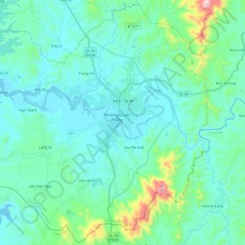
Name: Kon Tum topographic map, elevation, terrain.
Location: Kon Tum, Quảng Ngãi Province, Vietnam (14.22822 107.85000 14.45365 108.08841)
Average elevation: 609 m
Minimum elevation: 506 m
Maximum elevation: 1,191 m
Make a donation
Gear up for your next adventure:
As an Amazon Associate, this site earns from qualifying purchases at no extra cost to you.
Other topographic maps
Click on a map to view its topography, its elevation and its terrain.
Make a donation
Gear up for your next adventure:
As an Amazon Associate, this site earns from qualifying purchases at no extra cost to you.
Make a donation
Gear up for your next adventure:
As an Amazon Associate, this site earns from qualifying purchases at no extra cost to you.
Make a donation
Gear up for your next adventure:
As an Amazon Associate, this site earns from qualifying purchases at no extra cost to you.