
Akkar District topographic map
Interactive map
Click on the map to display elevation.
About this map
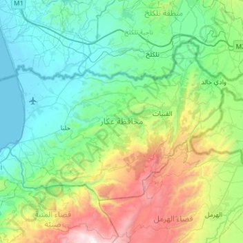
Name: Akkar District topographic map, elevation, terrain.
Location: Akkar District, Akkar Governorate, Lebanon (34.41919 35.95451 34.69214 36.46493)
Average elevation: 636 m
Minimum elevation: 0 m
Maximum elevation: 2,736 m
Other topographic maps
Click on a map to view its topography, its elevation and its terrain.
Shadra
The population is Greek Orthodox and other Christian. The village is situated at a distance of 146km from Beirut at an altitude of 450 m above sea level. It has an area of 651 hectares, surrounded by Akroum from the east, the west Owainat, from the north Machta Hassan and Andaket from the south . Can be…
Average elevation: 516 m