
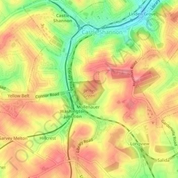
Bethel Green topographic map
Interactive map
Click on the map to display elevation.
About this map
Name: Bethel Green topographic map, elevation, terrain.
Average elevation: 359 m
Minimum elevation: 304 m
Maximum elevation: 397 m
Other topographic maps
Click on a map to view its topography, its elevation and its terrain.
Pittsburgh
United States of America > Pennsylvania > Pittsburgh
The warmest month of the year in Pittsburgh is July, with a 24-hour average of 72.6 °F (22.6 °C). Conditions are often humid, and combined with highs reaching 90 °F (32 °C) on an average 9.5 days a year, a considerable heat index arises. The coolest month is January, when the 24-hour average is 28.4 °F…
Average elevation: 315 m
Neshaminy
United States of America > Pennsylvania > Warrington Township > Neshaminy
Average elevation: 86 m
Upper Black Eddy
United States of America > Pennsylvania > Bridgeton Township > Upper Black Eddy
Average elevation: 100 m
Gilbertsville
United States of America > Pennsylvania > Douglass Township > Gilbertsville
Average elevation: 97 m
Gettysburg National Military Park
United States of America > Pennsylvania > Gettysburg
Average elevation: 166 m
Panorama Village
United States of America > Pennsylvania > College Township > Panorama Village
Average elevation: 350 m
Leibeyville
United States of America > Pennsylvania > West Penn Township > Leibeyville
Average elevation: 242 m
Hanover Acres
United States of America > Pennsylvania > Allentown > Hanover Acres
Average elevation: 109 m
Stoopville
United States of America > Pennsylvania > Newtown Township > Stoopville
Average elevation: 86 m
Pricetown
United States of America > Pennsylvania > Ruscombmanor Township > Pricetown
Average elevation: 239 m
Everbreeze Plateau
United States of America > Pennsylvania > Tinicum Township > Everbreeze Plateau
Average elevation: 96 m
Bear Creek Junction
United States of America > Pennsylvania > Bear Creek Junction
Average elevation: 404 m