Geolocate

Cottonwood topographic map

Interactive map

Click on the map to display elevation.

About this map

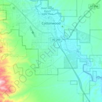
Name: Cottonwood topographic map, elevation, terrain.

Location: Cottonwood, Yavapai County, Arizona, 86236, United States (34.65068 -112.05372 34.76554 -111.94872)

Average elevation: 1,118 m

Minimum elevation: 969 m

Maximum elevation: 1,836 m

Other topographic maps

Click on a map to view its topography, its elevation and its terrain.

Cathedral Rock

United States > Arizona > Yavapai County

Cathedral Rock is a natural sandstone butte near Sedona, Arizona, and one of the most-photographed sights in Arizona, United States. The rock formation is located in the Coconino National Forest in Yavapai County, about 1 mi (1.6 km) west of Arizona Route 179, and about 2.5 mi (4.0 km) south of the "Y"…

Average elevation: 1,282 m

Needed Tank

United States > Arizona > Yavapai County

Average elevation: 1,763 m

Wilhoit

United States > Arizona > Yavapai County

Average elevation: 1,416 m

Packer (Site)

United States > Arizona > Yavapai County

Average elevation: 1,328 m

Iron Springs

United States > Arizona > Yavapai County

Average elevation: 1,828 m

Lake Montezuma

United States > Arizona > Yavapai County > Rimrock

Average elevation: 1,084 m

Wilhoit

United States > Arizona > Yavapai County

Average elevation: 1,520 m

Audley

United States > Arizona > Yavapai County

Average elevation: 1,589 m

Skull Valley

United States > Arizona > Yavapai County

Average elevation: 1,342 m

Peeples Valley

United States > Arizona > Yavapai County

Average elevation: 1,472 m

Rimrock

United States > Arizona > Yavapai County

Average elevation: 1,092 m

Ash Fork

United States > Arizona > Yavapai County

Average elevation: 1,561 m

Glen Oaks

United States > Arizona > Yavapai County

Average elevation: 1,717 m

Cordes

United States > Arizona > Yavapai County

Average elevation: 1,170 m

Ocotillo

United States > Arizona > Yavapai County

Average elevation: 1,302 m

Wagoner

United States > Arizona > Yavapai County > Wagoner

Average elevation: 1,063 m

Ash Fork

United States > Arizona > Yavapai County > Ash Fork

Average elevation: 1,561 m

Pica

United States > Arizona > Yavapai County

Average elevation: 1,613 m

Cleator

United States > Arizona > Yavapai County

Average elevation: 1,083 m

Dewey

United States > Arizona > Yavapai County > Prescott Valley > Dewey

Average elevation: 1,415 m