
Make a donation
Gear up for your next adventure:
As an Amazon Associate, this site earns from qualifying purchases at no extra cost to you.
Holmbury St Mary topographic map
Click on the map to display elevation.
Make a donation
Gear up for your next adventure:
As an Amazon Associate, this site earns from qualifying purchases at no extra cost to you.
About this map
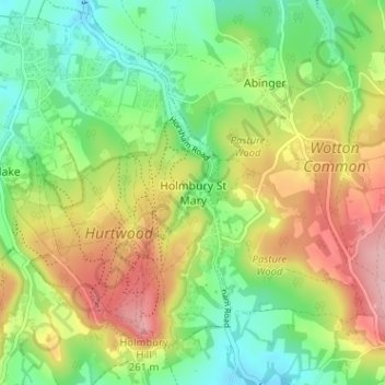
Name: Holmbury St Mary topographic map, elevation, terrain.
Average elevation: 168 m
Minimum elevation: 101 m
Maximum elevation: 263 m
Surrey trails, hiking, mountain biking, running and outdoor activities
Make a donation
Gear up for your next adventure:
As an Amazon Associate, this site earns from qualifying purchases at no extra cost to you.
Other topographic maps
Click on a map to view its topography, its elevation and its terrain.
Shalford
United Kingdom > England > Surrey > Guildford
Lt.Col. Henry Haversham Godwin-Austen (1834–1923), topographer, geologist, naturalist and explorer who surveyed the Himalayan region, including K2, sometimes known as Mt. Godwin-Austen, for a time had an estate in Shalford.
Average elevation: 54 m
Make a donation
Gear up for your next adventure:
As an Amazon Associate, this site earns from qualifying purchases at no extra cost to you.
Gunpowder Mills Fishery
United Kingdom > England > Surrey > Guildford > Chilworth
Average elevation: 84 m
Tillingbourne Trout Farm and Smokery
United Kingdom > England > Surrey > Guildford > Shere
Average elevation: 123 m
Make a donation
Gear up for your next adventure:
As an Amazon Associate, this site earns from qualifying purchases at no extra cost to you.
Make a donation
Gear up for your next adventure:
As an Amazon Associate, this site earns from qualifying purchases at no extra cost to you.
Make a donation
Gear up for your next adventure:
As an Amazon Associate, this site earns from qualifying purchases at no extra cost to you.
Make a donation
Gear up for your next adventure:
As an Amazon Associate, this site earns from qualifying purchases at no extra cost to you.
Shalford
United Kingdom > England > Surrey > Guildford
Lt.Col. Henry Haversham Godwin-Austen (1834–1923), topographer, geologist, naturalist and explorer who surveyed the Himalayan region, including K2, sometimes known as Mt. Godwin-Austen, for a time had an estate in Shalford.
Average elevation: 54 m
Make a donation
Gear up for your next adventure:
As an Amazon Associate, this site earns from qualifying purchases at no extra cost to you.
Make a donation
Gear up for your next adventure:
As an Amazon Associate, this site earns from qualifying purchases at no extra cost to you.