
Mountville topographic map
Interactive map
Click on the map to display elevation.
Mountville
On January 11, 1814, Isaac Rohrer laid out the town that became known as Mountville, dividing it into 130 building lots, sold by lottery. Located 4 miles (6 km) east of Columbia in West Hempfield Township on the Lancaster and Susquehanna Turnpike, Mountville was originally named "Mount Pleasant" because it was situated on an elevation affording a pleasant view of the surrounding countryside in every direction.
About this map
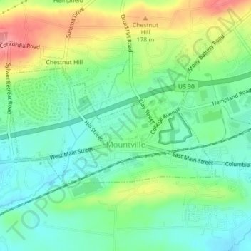
Name: Mountville topographic map, elevation, terrain.
Average elevation: 140 m
Minimum elevation: 107 m
Maximum elevation: 198 m
Other topographic maps
Click on a map to view its topography, its elevation and its terrain.
Pittsburgh
United States of America > Pennsylvania > Pittsburgh
The warmest month of the year in Pittsburgh is July, with a 24-hour average of 72.6 °F (22.6 °C). Conditions are often humid, and combined with highs reaching 90 °F (32 °C) on an average 9.5 days a year, a considerable heat index arises. The coolest month is January, when the 24-hour average is 28.4 °F…
Average elevation: 315 m
Neshaminy
United States of America > Pennsylvania > Warrington Township > Neshaminy
Average elevation: 86 m
Upper Black Eddy
United States of America > Pennsylvania > Bridgeton Township > Upper Black Eddy
Average elevation: 100 m
Gilbertsville
United States of America > Pennsylvania > Douglass Township > Gilbertsville
Average elevation: 97 m
Gettysburg National Military Park
United States of America > Pennsylvania > Gettysburg
Average elevation: 166 m
Panorama Village
United States of America > Pennsylvania > College Township > Panorama Village
Average elevation: 350 m
Leibeyville
United States of America > Pennsylvania > West Penn Township > Leibeyville
Average elevation: 242 m
Hanover Acres
United States of America > Pennsylvania > Allentown > Hanover Acres
Average elevation: 109 m
Stoopville
United States of America > Pennsylvania > Newtown Township > Stoopville
Average elevation: 86 m
Pricetown
United States of America > Pennsylvania > Ruscombmanor Township > Pricetown
Average elevation: 239 m
Everbreeze Plateau
United States of America > Pennsylvania > Tinicum Township > Everbreeze Plateau
Average elevation: 96 m
Bear Creek Junction
United States of America > Pennsylvania > Bear Creek Junction
Average elevation: 404 m