
Lafayette topographic map
Interactive map
Click on the map to display elevation.
About this map
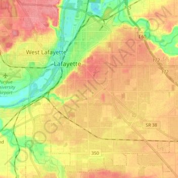
Name: Lafayette topographic map, elevation, terrain.
Location: Lafayette, Tippecanoe County, Indiana, United States (40.35549 -86.92611 40.45305 -86.79032)
Average elevation: 193 m
Minimum elevation: 152 m
Maximum elevation: 224 m
Lafayette is located at 40°24′38″N 86°52′29″W / 40.410585°N 86.874681°W / 40.410585; -86.874681 (40.410585, −86.874681) and is located in Fairfield and Wea Townships. Elevation at the court house is 550 feet (168 m), but city elevations range from a little over 500 feet (150 m) at the Wabash River to approximately 700 feet (210 m) in the areas of Murdock Park and Columbian Park.