
Eichstätt topographic map
Interactive map
Click on the map to display elevation.
About this map
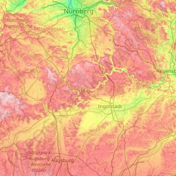
Name: Eichstätt topographic map, elevation, terrain.
Location: Eichstätt, Bavaria, 85072, Germany (48.19181 10.48501 49.59181 11.88501)
Average elevation: 455 m
Minimum elevation: 275 m
Maximum elevation: 734 m
Other topographic maps
Click on a map to view its topography, its elevation and its terrain.
Munich
Munich lies on the elevated plains of Upper Bavaria, about 50 km (31 mi) north of the northern edge of the Alps, at an altitude of about 520 m (1,706 ft) ASL. The local rivers are the Isar and the Würm. Munich is situated in the Northern Alpine Foreland. The northern part of this sandy plateau includes a…
Average elevation: 524 m
Neuschwanstein Castle
Germany > Bavaria > Landkreis Ostallgäu > Hohenschwangau
The municipality of Schwangau lies at an elevation of 800 m (2,620 ft) at the southwest border of the German state of Bavaria. Its surroundings are characterised by the transition between the Alpine foothills in the south (toward the nearby Austrian border) and a hilly landscape in the north that appears flat…
Average elevation: 982 m
Nuremberg
Nuremberg has an oceanic climate (Köppen Cfb) with a certain humid continental influence (Dfb), categorized in the latter by the 0 °C isotherm. The city's climate is influenced by its inland position and higher altitude. Winters are changeable, with either mild or cold weather: the average temperature is…
Average elevation: 336 m
97215
Germany > Bavaria > Landkreis Neustadt an der Aisch-Bad Windsheim > Uffenheim
Average elevation: 352 m
Munich
Munich lies on the elevated plains of Upper Bavaria, about 50 km (31 mi) north of the northern edge of the Alps, at an altitude of about 520 m (1,706 ft) ASL. The local rivers are the Isar and the Würm. Munich is situated in the Northern Alpine Foreland. The northern part of this sandy plateau includes a…
Average elevation: 524 m
Untersberg
Germany > Bavaria > Landkreis Berchtesgadener Land
Several trails lead to the top, though most people prefer the Untersbergbahn cable car. Constructed over a period of over two years, and opening in April 1961, the eight and a half minute journey lifts passengers from the lower terminus at the village of Sankt Leonhard at 456 m (1,496 ft) over 1,320 m (4,330…
Average elevation: 797 m
Schloss Sinning
Germany > Bavaria > Landkreis Neuburg-Schrobenhausen > Sinning
Average elevation: 432 m
Erlangen
In 1435 the church, which had been the daughter church of St. Martin in Forchheim up until this point, was elevated to its own parish. The main task of the Erlangen priest was the pastoral care in the city of Erlangen and the St. Martin's Chapel on the Martinsbühl, which was now named for the first time.…
Average elevation: 300 m
Passau
On 2 June 2013, the old town suffered from severe flooding as a result of several days of rain and its location at the confluence of three rivers. Peak elevations of floods as early as 1501 are displayed on a wall at the Old City Hall. Flood water reaches the base of that wall on average once every 5 years.
Average elevation: 401 m
Schweinfurt
Schweinfurt itself is also a city of great contrasts, in terms of topography, use and population structure. The bourgeois east lies on the foothills of the Schweinfurter Rhön, is intersected by valleys with streams, with the above the Marienbach located old town and numerous detached houses, on the edge with…
Average elevation: 251 m
92318
Germany > Bavaria > Landkreis Neumarkt in der Oberpfalz > Neumarkt in der Oberpfalz > Höhenberg im Tal
Average elevation: 492 m
85283
Germany > Bavaria > Landkreis Pfaffenhofen an der Ilm > Wolnzach > Jebertshausen
Average elevation: 451 m
90518
Germany > Bavaria > Nürnberger Land > Altdorf bei Nürnberg > Oberwellitzleithen
Average elevation: 448 m
Nuremberg
Nuremberg has an oceanic climate (Köppen Cfb) with a certain humid continental influence (Dfb), categorized in the latter by the 0 °C isotherm. The city's climate is influenced by its inland position and higher altitude. Winters are changeable, with either mild or cold weather: the average temperature is…
Average elevation: 336 m
Untersberg
Germany > Bavaria > Landkreis Berchtesgadener Land
Several trails lead to the top, though most people prefer the Untersbergbahn cable car. Constructed over a period of over two years, and opening in April 1961, the eight and a half minute journey lifts passengers from the lower terminus at the village of Sankt Leonhard at 456 m (1,496 ft) over 1,320 m (4,330…
Average elevation: 797 m
Moosburg
Germany > Bavaria > Landkreis Freising
The oldest town between Regensburg and Italy, it lies on the river Isar at an altitude of 421 m (1381 ft). It has 20,237 inhabitants (2022) and covers an area of 44 km2. It is easily reached by the A 92 autobahn and regional trains on the Munich–Regensburg line. Furthermore, it takes just 20 minutes to get…
Average elevation: 428 m
Partnach Gorge
Germany > Bavaria > Landkreis Garmisch-Partenkirchen > Garmisch-Partenkirchen > Vordergraseck
Average elevation: 1,004 m
Nuremberg
Nuremberg has an oceanic climate (Köppen Cfb) with a certain humid continental influence (Dfb), categorized in the latter by the 0 °C isotherm. The city's climate is influenced by its inland position and higher altitude. Winters are changeable, with either mild or cold weather: the average temperature is…
Average elevation: 336 m