
Salem County topographic map
Interactive map
Click on the map to display elevation.
Salem County
The terrain is almost uniformly flat coastal plain, with minimal relief. The highest elevation in the county has never been determined with any specificity, but is likely one of seven low rises in Upper Pittsgrove Township that reach approximately 160 feet (49 m) in elevation. Sea level is the lowest point.
About this map
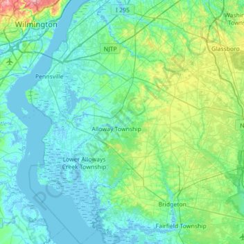
Name: Salem County topographic map, elevation, terrain.
Location: Salem County, New Jersey, United States (39.35592 -75.56339 39.78754 -75.06190)
Average elevation: 18 m
Minimum elevation: -5 m
Maximum elevation: 115 m
Other topographic maps
Click on a map to view its topography, its elevation and its terrain.
Stow Acres
United States > New Jersey > Burlington County > Evesham Township > Marlton
Average elevation: 24 m
Woolwich Township
United States > New Jersey > Gloucester County > Woolwich Township
Average elevation: 23 m
Rahway River West Branch
United States > New Jersey > Essex County > Short Hills
Average elevation: 73 m
Basking Ridge
United States > New Jersey > Somerset County > Bernards Township
Average elevation: 98 m
Columbia Lakes
United States > New Jersey > Camden County > Cherry Hill Township
Average elevation: 17 m
Remsterville
United States > New Jersey > Salem County > Alloway Township > Alloway Township
Average elevation: 15 m
Powder Mill Pond Dam
United States > New Jersey > Morris County > Parsippany-Troy Hills > Tabor
Average elevation: 178 m
Freneau Woods Park
United States > New Jersey > Monmouth County > Aberdeen Township > Henningers Mill
Average elevation: 23 m
Upper Mill
United States > New Jersey > Burlington County > Pemberton Township
Average elevation: 31 m
Mount Royal
United States > New Jersey > Gloucester County > East Greenwich Township
Average elevation: 11 m
Fostertown
United States > New Jersey > Burlington County > Lumberton Township
Average elevation: 14 m
Lincoln
United States > New Jersey > Gloucester County > South Harrison Township
Average elevation: 37 m
Washington Corner
United States > New Jersey > Morris County > Mendham Township
Average elevation: 174 m
Elmer B Boyd Park
United States > New Jersey > Middlesex County > New Brunswick > Feaster Park
Average elevation: 22 m
Hendrickson Corners
United States > New Jersey > Monmouth County > Middletown Township
Average elevation: 22 m
Emleys Hill
United States > New Jersey > Monmouth County > Upper Freehold Township
Average elevation: 46 m
Hillside Terrace
United States > New Jersey > Mercer County > Robbinsville Township
Average elevation: 35 m
Hendrickson Corners
United States > New Jersey > Monmouth County > Middletown Township
Average elevation: 22 m
Marlboro
United States > New Jersey > Burlington County > Evesham Township > Marlton
Average elevation: 26 m
Schooleys Mountain
United States > New Jersey > Morris County > Washington Township
Average elevation: 293 m
Burlington Heights
United States > New Jersey > Monmouth County > Freehold Township
Average elevation: 47 m
Marion
United States > New Jersey > Hudson County > Jersey City > Journal Square
Average elevation: 12 m
Croxton
United States > New Jersey > Hudson County > Jersey City > Journal Square
Average elevation: 16 m
High Rock Mountain
United States > New Jersey > Warren County > White Township
Average elevation: 189 m
Bearfort Mountain
United States > New Jersey > Passaic County > West Milford
At an elevation of 1,331 feet (406 m) the ridge is the site of a 68 feet (21 m) high fire lookout tower built by the New Jersey Forest Fire Service.
Average elevation: 354 m