
Lake of the Pines topographic map
Interactive map
Click on the map to display elevation.
Lake of the Pines
Lake of the Pines is commonly associated with a gated residential community which surrounds a reservoir, also named Lake of the Pines. The reservoir was created by damming Magnolia Creek, in the Bear River watershed, and it has a maximum elevation of 459 m (1507 ft). The gated community contains a golf course looping around the reservoir. The community is normally accessed only through the main entrance from Magnolia Road, just northeast of Combie Road.
About this map
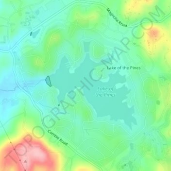
Name: Lake of the Pines topographic map, elevation, terrain.
Average elevation: 482 m
Minimum elevation: 439 m
Maximum elevation: 585 m
Other topographic maps
Click on a map to view its topography, its elevation and its terrain.
Truckee
United States > California > Nevada County
Truckee is characterized by its dramatic topography set in the Sierra Nevada mountain range. The town sits at an elevation of approximately 5,817 feet (1,774 meters), surrounded by a stunning landscape of rugged mountains, rolling hills, and expansive forested areas. Prominent features include Donner Pass,…
Average elevation: 1,918 m
Alta Sierra
United States > California > Nevada County > Alta Sierra
Alta Sierra was laid out by property developers in the 1960s. Alta Sierra is a golf course community, with homes built around the Alta Sierra Country Club, a semi-private 18 hole course built in 1964. The community has a member-owned airport with a 2800-foot runway. The community is located just east of…
Average elevation: 603 m
Grass Valley
United States > California > Nevada County
Grass Valley is a city in Nevada County, California, United States. Situated at roughly 2,500 feet (760 m) in elevation in the western foothills of the Sierra Nevada mountain range, this northern Gold Country city is 57 miles (92 km) by car from Sacramento, 64 miles (103 km) from Sacramento International…
Average elevation: 775 m
Alta Sierra
United States > California > Nevada County > Alta Sierra
Alta Sierra was laid out by property developers in the 1960s. Alta Sierra is a golf course community, with homes built around the Alta Sierra Country Club, a semi-private 18 hole course built in 1964. The community has a member-owned airport with a 2800 foot runway. The community is located just east of…
Average elevation: 603 m
Grass Valley
United States > California > Nevada County
Grass Valley is a city in Nevada County, California, United States. Situated at roughly 2,500 feet (760 m) in elevation in the western foothills of the Sierra Nevada mountain range, this northern Gold Country city is 57 miles (92 km) by car from Sacramento, 64 miles (103 km) from Sacramento International…
Average elevation: 775 m