
Make a donation
Gear up for your next adventure:
As an Amazon Associate, this site earns from qualifying purchases at no extra cost to you.
Gorontalo topographic map
Click on the map to display elevation.
Gear up for your next adventure:
As an Amazon Associate, this site earns from qualifying purchases at no extra cost to you.
Gorontalo
Topographically, the province is relatively low (0–40o), with the elevation ranging between 0–2,400 m (7,900 ft) above sea level. Its coastline length is more than 590 km (370 mi). Counting the Exclusive Economic Zone to the north where Philippines is at the border, the total sea area of the province is more than 50,500 km2 (19,500 sq mi). There are some small islands around the north and the south of the province, 67 of which have been identified and named.
Make a donation
Gear up for your next adventure:
As an Amazon Associate, this site earns from qualifying purchases at no extra cost to you.
About this map
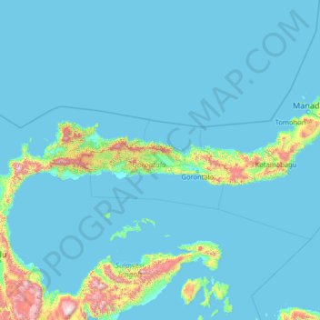
Name: Gorontalo topographic map, elevation, terrain.
Location: Gorontalo, Indonesia (-1.88138 119.85559 3.31862 125.05559)
Average elevation: 124 m
Minimum elevation: 0 m
Maximum elevation: 2,725 m
Make a donation
Gear up for your next adventure:
As an Amazon Associate, this site earns from qualifying purchases at no extra cost to you.
Other topographic maps
Click on a map to view its topography, its elevation and its terrain.
Java
The natural environment of Java is tropical rainforest, with ecosystems ranging from coastal mangrove forest on the north coast, rocky coastal cliffs on the southern coast, and low-lying tropical forest to high altitude rainforest on the slopes of mountainous volcanic regions in the interior. The Javan…
Average elevation: 41 m
Sulawesi
The lowland forests on the island have mostly been removed. Because of the relative geological youth of the island and its dramatic and sharp topography, the lowland areas are naturally limited in their extent. The past decade has seen dramatic conversion of this rare and endangered habitat. The island also…
Average elevation: 145 m
Make a donation
Gear up for your next adventure:
As an Amazon Associate, this site earns from qualifying purchases at no extra cost to you.
Buru Island
The Apo River is the longest river of Buru. It flows nearly straight to the north-east and empties into Kayeli Bay; however, its bed is very winding for hundreds of meters, with loops all along its length. Two other permanent rivers are Geren and Nibe; the rest are intermittent rivers with discontinuous flow.…
Average elevation: 236 m
Pulau Biak
Biak covers an area of 2,455 km2 (948 sq mi) The island is 72 km (45 mi) long and 37 km (23 mi) wide at its widest point. The highest point is approximately 740 meters elevation, located in the northwest of the island.
Average elevation: 49 m
Make a donation
Gear up for your next adventure:
As an Amazon Associate, this site earns from qualifying purchases at no extra cost to you.
Dusun Cilangkap, Desa Cisempur, Kec. Cibalong, Kab. Tasikmalaya
Indonesia > West Java > Tasikmalaya > Cisempur
Average elevation: 198 m
Komodo National Park
Indonesia > East Nusa Tenggara > Manggarai Barat
The park comprises a coastal section of western Flores, the three larger islands of Komodo, Padar and Rinca, 26 smaller islands and the surrounding waters of the Sape Straights. The islands of the national park are of volcanic origin. The terrain is generally rugged, characterized by rounded hills, with…
Average elevation: 38 m
Make a donation
Gear up for your next adventure:
As an Amazon Associate, this site earns from qualifying purchases at no extra cost to you.
Make a donation
Gear up for your next adventure:
As an Amazon Associate, this site earns from qualifying purchases at no extra cost to you.
RW 11 Kelurahan Merjosari Kecamatan Lowokwaru Kota Malang
Indonesia > East Java > Kota Malang > Malang
Average elevation: 597 m
Make a donation
Gear up for your next adventure:
As an Amazon Associate, this site earns from qualifying purchases at no extra cost to you.
Make a donation
Gear up for your next adventure:
As an Amazon Associate, this site earns from qualifying purchases at no extra cost to you.
Make a donation
Gear up for your next adventure:
As an Amazon Associate, this site earns from qualifying purchases at no extra cost to you.
Make a donation
Gear up for your next adventure:
As an Amazon Associate, this site earns from qualifying purchases at no extra cost to you.
Make a donation
Gear up for your next adventure:
As an Amazon Associate, this site earns from qualifying purchases at no extra cost to you.
Make a donation
Gear up for your next adventure:
As an Amazon Associate, this site earns from qualifying purchases at no extra cost to you.
Make a donation
Gear up for your next adventure:
As an Amazon Associate, this site earns from qualifying purchases at no extra cost to you.
Sungai Code
Indonesia > Special Region of Yogyakarta > Sleman Regency > Yogyakarta
Average elevation: 110 m
Make a donation
Gear up for your next adventure:
As an Amazon Associate, this site earns from qualifying purchases at no extra cost to you.
Make a donation
Gear up for your next adventure:
As an Amazon Associate, this site earns from qualifying purchases at no extra cost to you.
Sungai Pandan
Indonesia > West Nusa Tenggara > Lombok Tengah > Kecamatan Praya Barat Daya
Average elevation: 73 m
Make a donation
Gear up for your next adventure:
As an Amazon Associate, this site earns from qualifying purchases at no extra cost to you.
Make a donation
Gear up for your next adventure:
As an Amazon Associate, this site earns from qualifying purchases at no extra cost to you.
Pulau Maya
Indonesia > West Kalimantan > Kayong Utara
Maya Karimata (now just called Maya or Maja) is an island in North Kayong Regency in West Kalimantan Province, Indonesia. Its area is 992.1 square kilometres (383.1 square miles). Maya Island and the Karimata Islands formerly comprised a single administrative district (kecamatan) within the Regency, but it has…
Average elevation: 4 m
Make a donation
Gear up for your next adventure:
As an Amazon Associate, this site earns from qualifying purchases at no extra cost to you.
Karimunjawa National Park
The geological formation in the archipelago is mostly dominated by quartz sandstone, gravel, mud, and clay. The topography of Karimunjawa Marine National Park is a wave of low land, with elevation ranging from 0–506 meters above sea level. Gajah hill is the Park’s highest point. Temperatures range from…
Average elevation: 1 m
Make a donation
Gear up for your next adventure:
As an Amazon Associate, this site earns from qualifying purchases at no extra cost to you.
Make a donation
Gear up for your next adventure:
As an Amazon Associate, this site earns from qualifying purchases at no extra cost to you.
Badau
Indonesia > West Kalimantan > Kapuas Hulu
This district generally has a mountainous and hilly topography, with dense tropical forests. The climate conditions in Badau are generally tropical with quite high rainfall throughout the year, which supports the lush forest vegetation in the area. This district is crossed by several rivers including the Badau…
Average elevation: 61 m
Make a donation
Gear up for your next adventure:
As an Amazon Associate, this site earns from qualifying purchases at no extra cost to you.
Make a donation
Gear up for your next adventure:
As an Amazon Associate, this site earns from qualifying purchases at no extra cost to you.