
Java topographic map
Click on the map to display elevation.
Java
The natural environment of Java is tropical rainforest, with ecosystems ranging from coastal mangrove forest on the north coast, rocky coastal cliffs on the southern coast, and low-lying tropical forest to high altitude rainforest on the slopes of mountainous volcanic regions in the interior. The Javan environment and climate gradually alters from west to east; from wet and humid dense rainforest in western parts, to a dry savanna environment in the east, corresponding to the climate and rainfall in these regions.
About this map
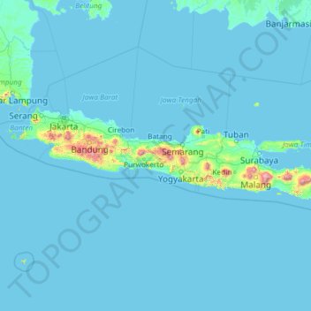
Name: Java topographic map, elevation, terrain.
Location: Java, Indonesia (-8.78042 105.20955 -5.87550 114.60539)
Average elevation: 41 m
Minimum elevation: -2 m
Maximum elevation: 3,329 m
Other topographic maps
Click on a map to view its topography, its elevation and its terrain.
Malang
Indonesia > East Java > Kota Malang > Malang
The city was capital city of Singhasari in 1222, then transferred to Dutch colony. Malang was modernized under the Dutch; its mild climate which results from its elevation, along with its proximity to the major port of Surabaya, made it a popular destination for the Dutch and other Europeans. Malang began to…
Average elevation: 657 m
Bali Island
Bali's central mountains include several peaks over 2,000 metres (6,600 feet) in elevation and active volcanoes such as Mount Batur. The highest is Mount Agung (3,031 m; 9,944 ft), known as the "mother mountain", which is an active volcano rated as one of the world's most likely sites for a massive eruption…
Average elevation: 357 m
Bandung
Bandung (Sundanese: ᮘᮔ᮪ᮓᮥᮀ, romanized: Bandung, Sundanese pronunciation: [ˈbandʊŋ]; /ˈbɑːndʊŋ/) is the capital city of the Indonesian province of West Java. It has a population of 2,452,943 within its city limits according to the official estimates as at mid 2021, making it the fourth most…
Average elevation: 879 m
Purwokerto
Indonesia > Central Java > Banyumas
Purwokerto is located in the middle of Java Island within the province of Central Java, near the base of Mount Slamet, the second-tallest mountain in Java. The average elevation is 183,87 meters, maximum 286 m, and minimum 71 meters above sea level. The city is bisected by the Kali Kranji (Kranji River). It…
Average elevation: 277 m
Kaliurang
Indonesia > Special Region of Yogyakarta > Sleman Regency > Hargobinangun
Average elevation: 858 m
Balikpapan
Topography of Balikpapan is generally hilly (85%), with only small areas of flat land (15%), mostly along the coast and surrounding the hilly areas. The hills are less than 100 meters (330 feet) higher than the adjacent valleys. The altitude of Balikpapan ranges from 0 to 80 meters (260 feet) above sea level.…
Average elevation: 10 m
Kepanjen
Indonesia > East Java > Kabupaten Malang
Kepanjen is located in south center of Malang Regency. Kepanjen has an average altitude of 336 metres (1,102 ft) above sea level. Kepanjen is surrounded by three large mountains: Mount Kawi, Mount Semeru and Southern Malang Mountains.
Average elevation: 337 m
Babadan
Indonesia > East Java > Kabupaten Malang > Dsn. Babadan, Ds. Babadan, Kecamatan Ngajum, Malang
Average elevation: 561 m
Waduk Cengklik
Indonesia > Central Java > Boyolali > Desa Ngargorejo > Ngargorejo
Average elevation: 137 m
Karimunjawa National Park
The geological formation in the archipelago is mostly dominated by quartz sandstone, gravel, mud, and clay. The topography of Karimunjawa Marine National Park is a wave of low land, with elevation ranging from 0–506 meters above sea level. Gajah hill is the Park’s highest point. Temperatures range from…
Average elevation: 1 m
Bogor
The city is situated in the western part of Java island, about 53 km south of the capital Jakarta and 85 km northwest of Bandung, the administrative center of West Java Province. Bogor spreads over a basin near volcanoes Salak, which peaks at about 12 km south, and Mount Gede whose top is 22–25 km south-east…
Average elevation: 442 m
Dsn. Blau Ds. Permanu Kec. Pakisaji, Malang
Indonesia > East Java > Kabupaten Malang
Average elevation: 478 m
Mount Agung
Indonesia > Bali > Karangasem
Australia's Bureau of Meteorology reported on 27 November that ash from the eruption had been observed at an altitude of 9,144 m. By the beginning of December, the eruption reduced to minor emissions of steam and smoke. On 12 December, a picture of the crater was taken showing a steadily growing lava dome…
Average elevation: 2,534 m
RW 11 Kelurahan Merjosari Kecamatan Lowokwaru Kota Malang
Indonesia > East Java > Kota Malang > Malang
Average elevation: 597 m