Geolocate

Gorontalo topographic map

Interactive map

Click on the map to display elevation.

Gorontalo

Topographically, the province is relatively low (0–40o), with the elevation ranging between 0–2,400 m (7,900 ft) above sea level. Its coastline length is more than 590 km (370 mi). Counting the Exclusive Economic Zone to the north where Philippines is at the border, the total sea area of the province is more than 50,500 km2 (19,500 sq mi). There are some small islands around the north and the south of the province, 67 of which have been identified and named.

About this map

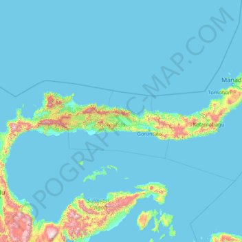
Name: Gorontalo topographic map, elevation, terrain.

Location: Gorontalo, Indonesia (-1.88138 119.85559 3.31862 125.05559)

Average elevation: 124 m

Minimum elevation: 0 m

Maximum elevation: 2,725 m

Other topographic maps

Click on a map to view its topography, its elevation and its terrain.

Java

Indonesia

The natural environment of Java is tropical rainforest, with ecosystems ranging from coastal mangrove forest on the north coast, rocky coastal cliffs on the southern coast, and low-lying tropical forest to high altitude rainforest on the slopes of mountainous volcanic regions in the interior. The Javan…

Average elevation: 41 m

Sumatra

Indonesia

Average elevation: 93 m

Gili Air

Indonesia > West Nusa Tenggara > Mataram

Average elevation: 1 m

Sulawesi

Indonesia

The lowland forests on the island have mostly been removed. Because of the relative geological youth of the island and its dramatic and sharp topography, the lowland areas are naturally limited in their extent. The past decade has seen dramatic conversion of this rare and endangered habitat. The island also…

Average elevation: 145 m

Pulau Biak

Indonesia > Papua > Supiori

Biak covers an area of 2,455 km2 (948 sq mi) The island is 72 km (45 mi) long and 37 km (23 mi) wide at its widest point. The highest point is approximately 740 meters elevation, located in the northwest of the island.

Average elevation: 49 m

Galesong

Indonesia > South Sulawesi

Average elevation: 7 m

Bentiring

Indonesia > Bengkulu > Bengkulu

Average elevation: 12 m

Burangrang

Indonesia > West Java > Bandung City

Average elevation: 695 m

Done

Indonesia > East Nusa Tenggara > Sikka

Average elevation: 402 m

Menukung

Indonesia > West Kalimantan > Melawi

Average elevation: 265 m

Kopo

Indonesia > West Java > Bandung City

Average elevation: 691 m

Palu Island

Indonesia > East Nusa Tenggara > Sikka > Nitung Lea

Average elevation: 195 m

Jabon

Indonesia > East Java > Sidoarjo

Average elevation: 4 m

Pulau Banyak Barat

Indonesia > Aceh > Aceh Singkil

Average elevation: 6 m

Pulau Banyak

Indonesia > Aceh > Aceh Singkil

Average elevation: 0 m

South Kalimantan

Indonesia

Average elevation: 30 m

Kariangau

Indonesia > East Kalimantan > Balikpapan

Average elevation: 25 m

Indramayu

Indonesia > West Java

Average elevation: 40 m

Tondano

Indonesia > North Sulawesi > Minahasa Utara > Manado

Average elevation: 40 m

Karang Joang

Indonesia > East Kalimantan > Balikpapan

Average elevation: 29 m

Yamo River

Indonesia > Central Papua

Average elevation: 2,456 m

Jejel

Indonesia > East Java > Lamongan > Ngimbang

Average elevation: 80 m

Ketambe

Indonesia > Aceh > Aceh Tenggara

Average elevation: 1,323 m

Pungging

Indonesia > East Java > Mojokerto

Average elevation: 22 m

WAY SEMAKA

Indonesia > Lampung > Lampung Barat > Sukarame

Average elevation: 802 m

Sumbawa Barat

Indonesia > West Nusa Tenggara

Average elevation: 239 m

Gandus

Indonesia > South Sumatra > Palembang

Average elevation: 7 m

Kecamatan Kabila

Indonesia > Gorontalo > Bone Bolango

Average elevation: 17 m

Desa Tanamanang

Indonesia > East Nusa Tenggara

Average elevation: 64 m

Atu Lintang

Indonesia > Aceh > Aceh Tengah

Average elevation: 1,528 m

Medan Sunggal

Indonesia > North Sumatra > City of Medan

Average elevation: 26 m

Sungai Kecil

Indonesia > Riau Islands > Batam > Batu Aji

Average elevation: 25 m

Pameungpeuk

Indonesia > West Java > Garut

Average elevation: 123 m

Binjai Hulu

Indonesia > West Kalimantan > Sintang

Average elevation: 27 m

Larangan

Indonesia > Banten > Tangerang

Average elevation: 22 m

Setu

Indonesia > Banten > South Tangerang

Average elevation: 51 m

Muara Beliti

Indonesia > South Sumatra > Musi Rawas

Average elevation: 77 m

Sematang Borang

Indonesia > South Sumatra > Palembang

Average elevation: 5 m

Kendawangan

Indonesia > West Kalimantan > Ketapang

Average elevation: 12 m

Kecamatan Tatanga

Indonesia > Central Sulawesi

Average elevation: 71 m

Seunagan

Indonesia > Aceh > Nagan Raya

Average elevation: 40 m

Balaraja

Indonesia > Banten > Tangerang Regency

Average elevation: 18 m

Pagedangan

Indonesia > Banten > Tangerang Regency

Average elevation: 40 m

Ciawi

Indonesia > West Java > Bogor

Average elevation: 758 m

Karang Pilang

Indonesia > East Java > Surabaya

Average elevation: 9 m

Sungai Kunjang

Indonesia > East Kalimantan > Samarinda

Average elevation: 20 m

Tiom River

Indonesia > Highland Papua > Lanny Jaya > Tiom

Average elevation: 2,805 m

Pasaman

Indonesia > West Sumatra

Average elevation: 552 m

Cibodas

Indonesia > West Java > Garut

Average elevation: 1,315 m

Sukatani

Indonesia > West Java > Garut

Average elevation: 1,166 m

Bogor Selatan

Indonesia > West Java > Bogor

Average elevation: 377 m

Tanah Sareal

Indonesia > West Java > Bogor

Average elevation: 182 m

Sekadau Hilir

Indonesia > West Kalimantan > Sekadau

Average elevation: 39 m

Kecamatan Pinggir

Indonesia > Riau > Bengkalis

Average elevation: 20 m

Kecamatan Kemuning

Indonesia > Riau > Indragiri Hilir

Average elevation: 110 m

Anai River

Indonesia > West Sumatra > Tanah Datar

Average elevation: 614 m

Penida Island

Indonesia > Bali > Klungkung Regency > Batukandik

Nusa Penida (Balinese: ᬦᬸᬲᬧᭂᬦᬶᬤ, romanized: nusa pĕnida) is an island located near the southeastern Indonesian island of Bali, which forms a district of the same name in Klungkung Regency. The Badung Strait separates the island and Bali. The interior of Nusa Penida is hilly with a maximum…

Average elevation: 104 m

Lais

Indonesia > South Sumatra > Musi Banyuasin

Average elevation: 14 m

Jerowaru

Indonesia > West Nusa Tenggara

Average elevation: 22 m

Lake Towuti

Indonesia > South Sulawesi

Average elevation: 469 m

Desa Babakan

Indonesia > West Java > Pangandaran

Average elevation: 11 m

Kecamatan Bebandem

Indonesia > Bali > Karangasem

Average elevation: 735 m

Sambas

Indonesia > West Kalimantan > Sambas

Average elevation: 11 m

Sanga Desa

Indonesia > South Sumatra

Average elevation: 28 m

Kecamatan Dumai Timur

Indonesia > Riau > Dumai City

Average elevation: 5 m

Kecamatan Pariangan

Indonesia > West Sumatra > Tanah Datar

Average elevation: 1,011 m

Kecamatan X Koto

Indonesia > West Sumatra > Tanah Datar

Average elevation: 839 m

Kubu

Indonesia > West Kalimantan > Kubu Raya

Average elevation: 4 m

Babakan Madang

Indonesia > West Java > Bogor

Average elevation: 313 m

Bandung Wetan

Indonesia > West Java > Bandung City

Average elevation: 725 m

Kalijambe

Indonesia > Central Java > Purworejo

Average elevation: 338 m