
Негровець topographic map
Interactive map
Click on the map to display elevation.
About this map
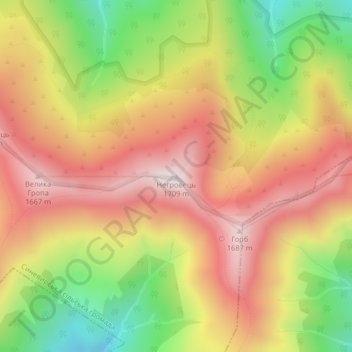
Name: Негровець topographic map, elevation, terrain.
Location: Негровець, Mizhhirya Raion, Zakarpattia Oblast, Ukraine (48.49824 23.71512 48.49834 23.71522)
Average elevation: 1,387 m
Minimum elevation: 1,008 m
Maximum elevation: 1,695 m
Other topographic maps
Click on a map to view its topography, its elevation and its terrain.
Ancient and Primeval Beech Forests of the Carpathians and Other Regions of Europe
Average elevation: 467 m
Ancient and Primeval Beech Forests of the Carpathians and Other Regions of Europe
Average elevation: 467 m