
Araújos topographic map
Interactive map
Click on the map to display elevation.
About this map
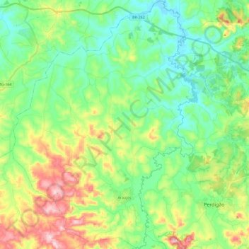
Name: Araújos topographic map, elevation, terrain.
Average elevation: 791 m
Minimum elevation: 687 m
Maximum elevation: 1,021 m
The city center of Araújos is located at an elevation of 821 meters about halfway between Divinópolis and Bom Despacho. Neighboring municipalities are: Bom Despacho (N) and (NW), Leandro Ferreira (NE), Nova Serrana and Pedigão (E), Santo Antônio do Monte (S) and (SW).