Geolocate

Little Pine Lagoon topographic map

Interactive map

Click on the map to display elevation.

About this map

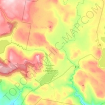
Name: Little Pine Lagoon topographic map, elevation, terrain.

Location: Little Pine Lagoon, Central Highlands, Tasmania, Australia (-42.03257 146.49667 -41.91206 146.64647)

Average elevation: 1,054 m

Minimum elevation: 869 m

Maximum elevation: 1,224 m

Other topographic maps

Click on a map to view its topography, its elevation and its terrain.

Tasman Peninsula

Australia > Tasmania > Tasman > Fortescue

Average elevation: 167 m

Mount Kate

Australia > Tasmania

Average elevation: 995 m

Mount Jukes

Australia > Tasmania

Average elevation: 773 m

Frog Hill

Australia > Tasmania

Average elevation: 875 m

Highland Waters

Australia > Tasmania > London Lakes

Average elevation: 759 m

Bullock Hill

Australia > Tasmania > Grove

Average elevation: 147 m

Ulverstone

Australia > Tasmania > Ulverstone

Average elevation: 37 m

Recherche Bay

Australia > Tasmania

Average elevation: 10 m

Bastyan Dam

Australia > Tasmania > Tullah

Average elevation: 233 m

New Town Bay

Australia > Tasmania > Hobart

Average elevation: 17 m

Adelaide River

Australia > Tasmania

Average elevation: 582 m

Moulting Bay

Australia > Tasmania

Average elevation: 23 m

Legges Tor

Australia > Tasmania

Average elevation: 1,457 m

Rowlands Hill

Australia > Tasmania

Average elevation: 388 m

Stillwater Hill

Australia > Tasmania

Average elevation: 353 m