
Flat Rock topographic map
Interactive map
Click on the map to display elevation.
About this map
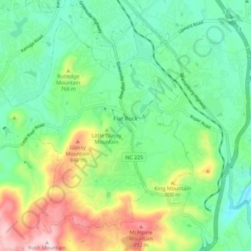
Name: Flat Rock topographic map, elevation, terrain.
Location: Flat Rock, Henderson County, North Carolina, United States (35.24084 -82.50104 35.29774 -82.41956)
Average elevation: 702 m
Minimum elevation: 589 m
Maximum elevation: 945 m
Other topographic maps
Click on a map to view its topography, its elevation and its terrain.
Wildwood Heights
United States > North Carolina > Henderson County > Laurel Park
Average elevation: 757 m
Mills River
United States > North Carolina > Henderson County > Mills River > Oak Hill Court
Average elevation: 644 m
Flat Rock Forest
United States > North Carolina > Henderson County > Flat Rock > Flat Rock Forest
Average elevation: 681 m
Claremont
United States > North Carolina > Henderson County > Flat Rock > Claremont
Average elevation: 713 m
Mills River
United States > North Carolina > Henderson County > Mills River > Oak Hill Court
Average elevation: 633 m