
Make a donation
Gear up for your next adventure:
As an Amazon Associate, this site earns from qualifying purchases at no extra cost to you.
Flat Rock topographic map
Click on the map to display elevation.
Make a donation
Gear up for your next adventure:
As an Amazon Associate, this site earns from qualifying purchases at no extra cost to you.
About this map
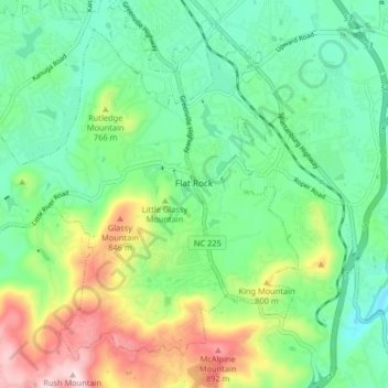
Name: Flat Rock topographic map, elevation, terrain.
Location: Flat Rock, Henderson County, North Carolina, United States (35.24084 -82.50104 35.29774 -82.41956)
Average elevation: 702 m
Minimum elevation: 589 m
Maximum elevation: 945 m
Make a donation
Gear up for your next adventure:
As an Amazon Associate, this site earns from qualifying purchases at no extra cost to you.
Other topographic maps
Click on a map to view its topography, its elevation and its terrain.
Make a donation
Gear up for your next adventure:
As an Amazon Associate, this site earns from qualifying purchases at no extra cost to you.
Edneyville
United States > North Carolina > Henderson County
Edneyville is in northeastern Henderson County at an elevation of 2,246 feet (685 m) above sea level. The Eastern Continental Divide runs through the center of the CDP; the eastern side of the community drains via Reedypatch Creek to the Broad River, which flows through the Congaree and Santee River systems to…
Average elevation: 689 m
Make a donation
Gear up for your next adventure:
As an Amazon Associate, this site earns from qualifying purchases at no extra cost to you.
Chanteloupe Country Estates
United States > North Carolina > Henderson County > Flat Rock
Average elevation: 660 m
Make a donation
Gear up for your next adventure:
As an Amazon Associate, this site earns from qualifying purchases at no extra cost to you.
Make a donation
Gear up for your next adventure:
As an Amazon Associate, this site earns from qualifying purchases at no extra cost to you.
Make a donation
Gear up for your next adventure:
As an Amazon Associate, this site earns from qualifying purchases at no extra cost to you.
Claremont
United States > North Carolina > Henderson County > Flat Rock > Claremont
Average elevation: 713 m
Mills River
United States > North Carolina > Henderson County > Mills River > Oak Hill Court
Average elevation: 644 m
Make a donation
Gear up for your next adventure:
As an Amazon Associate, this site earns from qualifying purchases at no extra cost to you.
Flat Rock Forest
United States > North Carolina > Henderson County > Flat Rock > Flat Rock Forest
Average elevation: 681 m