
Make a donation
Gear up for your next adventure:
As an Amazon Associate, this site earns from qualifying purchases at no extra cost to you.
Edneyville topographic map
Click on the map to display elevation.
Make a donation
Gear up for your next adventure:
As an Amazon Associate, this site earns from qualifying purchases at no extra cost to you.
Edneyville
Edneyville is in northeastern Henderson County at an elevation of 2,246 feet (685 m) above sea level. The Eastern Continental Divide runs through the center of the CDP; the eastern side of the community drains via Reedypatch Creek to the Broad River, which flows through the Congaree and Santee River systems to the Atlantic Ocean, while the western side of the community drains to Clear Creek, which flows via Mud Creek to the French Broad River, then the Tennessee River, and finally the Mississippi River to the Gulf of Mexico.
Make a donation
Gear up for your next adventure:
As an Amazon Associate, this site earns from qualifying purchases at no extra cost to you.
About this map
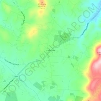
Name: Edneyville topographic map, elevation, terrain.
Location: Edneyville, Henderson County, North Carolina, United States (35.37401 -82.36095 35.41401 -82.32095)
Average elevation: 689 m
Minimum elevation: 604 m
Maximum elevation: 869 m
Make a donation
Gear up for your next adventure:
As an Amazon Associate, this site earns from qualifying purchases at no extra cost to you.
Other topographic maps
Click on a map to view its topography, its elevation and its terrain.
Make a donation
Gear up for your next adventure:
As an Amazon Associate, this site earns from qualifying purchases at no extra cost to you.
Etowah
United States > North Carolina > Henderson County
Etowah has an altitude of 2,101 feet (640 m).
Average elevation: 652 m
Make a donation
Gear up for your next adventure:
As an Amazon Associate, this site earns from qualifying purchases at no extra cost to you.
Make a donation
Gear up for your next adventure:
As an Amazon Associate, this site earns from qualifying purchases at no extra cost to you.
Mills River
United States > North Carolina > Henderson County > Mills River > Oak Hill Court
Average elevation: 644 m
Make a donation
Gear up for your next adventure:
As an Amazon Associate, this site earns from qualifying purchases at no extra cost to you.