
Milltown topographic map
Interactive map
Click on the map to display elevation.
About this map
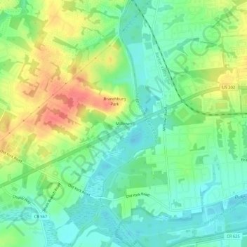
Name: Milltown topographic map, elevation, terrain.
Average elevation: 34 m
Minimum elevation: 11 m
Maximum elevation: 70 m
Other topographic maps
Click on a map to view its topography, its elevation and its terrain.
Bernardsville
United States > New Jersey > Somerset County
Bernardsville has a climate that borders between Humid continental and Humid subtropical with cool sometimes cold winters and warm to hot, humid summers on average. High elevations of the town have a warm summer humid continental climate with more snow during the winter and more orographic precipitation.…
Average elevation: 142 m
Peapack-Gladstone
United States > New Jersey > Somerset County > Peapack-Gladstone
Average elevation: 106 m
Bernards Township
United States > New Jersey > Somerset County > Bernards Township
Average elevation: 105 m
North Plainfield
United States > New Jersey > Somerset County > North Plainfield
Average elevation: 43 m