
Pendleton County topographic map
Interactive map
Click on the map to display elevation.
Pendleton County
Spruce Knob, located in Pendleton County, is the highest point in the state and in the Alleghenies, its elevation being 4,863 feet. Parts of the Monongahela and George Washington National Forests are also located in Pendleton County.
About this map
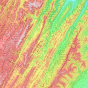
Name: Pendleton County topographic map, elevation, terrain.
Location: Pendleton County, West Virginia, United States (38.41188 -79.64988 38.95751 -79.05725)
Average elevation: 816 m
Minimum elevation: 286 m
Maximum elevation: 1,470 m
Other topographic maps
Click on a map to view its topography, its elevation and its terrain.
Mason-Dixon Historical Park
United States > West Virginia > Monongalia County > Holman
Average elevation: 330 m
White Top
United States > West Virginia > Randolph County
White Top is a knob and spur of Cheat Mountain in southeastern Randolph County, West Virginia, USA. Sitting at an elevation of 4,085 feet (1,245 m), it is located just west of the Shavers Fork of Cheat River and Cheat Bridge. While White Top was originally crossed by the Staunton–Parkersburg Turnpike,…
Average elevation: 1,159 m
Spruce Knob
United States > West Virginia > Pendleton County
Spruce Mountain, located in eastern West Virginia, is the highest ridge of the Allegheny Mountains. The whale-backed ridge extends for only 16 miles (26 km) from northeast to southwest, but several of its peaks exceed 4,500 feet (1,400 m) in elevation. The summit, Spruce Knob (4,863 ft; 1,482 m), is the…
Average elevation: 1,274 m
Alderson Recreation Area
United States > West Virginia > Greenbrier County > Alderson
Average elevation: 501 m