
Make a donation
Gear up for your next adventure:
As an Amazon Associate, this site earns from qualifying purchases at no extra cost to you.
Vila do Topo topographic map
Click on the map to display elevation.
Make a donation
Gear up for your next adventure:
As an Amazon Associate, this site earns from qualifying purchases at no extra cost to you.
About this map
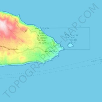
Name: Vila do Topo topographic map, elevation, terrain.
Location: Vila do Topo, Calheta, Azores, 9875-168, Portugal (38.50629 -27.80582 38.58629 -27.72582)
Average elevation: 60 m
Minimum elevation: 0 m
Maximum elevation: 575 m
Make a donation
Gear up for your next adventure:
As an Amazon Associate, this site earns from qualifying purchases at no extra cost to you.
Other topographic maps
Click on a map to view its topography, its elevation and its terrain.
Madeira
The archipelago includes the islands of Madeira, Porto Santo, and the Desertas, administered together with the separate archipelago of the Savage Islands. Roughly half of the region's population lives in its capital, Funchal. The region has political and administrative autonomy through the Administrative…
Average elevation: 5 m
Azores
The same can not be said for the higher altitudes (e.g. Mount Pico), where upper air masses of a continental origin and with a more direct pathway can reach the surface and present those areas with drier air and more extreme temperatures. At the same time, this free atmosphere circulating air transports…
Average elevation: 2 m
Make a donation
Gear up for your next adventure:
As an Amazon Associate, this site earns from qualifying purchases at no extra cost to you.
Algarve
The Algarve is located in the southernmost area of continental Portugal and the southwesternmost area of the Iberian Peninsula and mainland Europe, covering an area of 4,997 km2 (1,929 sq mi). It borders to the north with the Alentejo region (Alentejo Litoral and Baixo Alentejo), to the south and west with the…
Average elevation: 99 m
Make a donation
Gear up for your next adventure:
As an Amazon Associate, this site earns from qualifying purchases at no extra cost to you.
São Miguel Island
The highest elevation on São Miguel is the Pico da Vara at 1,103 metres (3,619 ft). Lying at the eastern end of the island, it is the focus of a Special Protection Area containing the largest remnant of laurisilva forest on the island, which is home to the endemic and critically endangered bird, the Azores…
Average elevation: 61 m
Make a donation
Gear up for your next adventure:
As an Amazon Associate, this site earns from qualifying purchases at no extra cost to you.
Vila Real
Located in a promontory formed by the gorges of the Corgo and Cabril rivers, Vila Real sits at 460 m (1,510 ft) altitude. The Alvão and Marão mountains overlook the town on the northwest and southwest side, respectively, rising up to 1,400 m (4,600 ft).
Average elevation: 682 m
Évora
Évora (altitude 300m) is situated in Alentejo, a large region of wide plains in the south of Portugal, bordered to the North by the Tagus River and to the South by the region of Algarve. The city is 140 km (87 mi) from the capital city Lisbon, and 80 km (50 mi) from Badajoz at the Spanish border. It is the…
Average elevation: 247 m
Make a donation
Gear up for your next adventure:
As an Amazon Associate, this site earns from qualifying purchases at no extra cost to you.
Coimbra
Despite being relatively distant from the coast, Coimbra also has a marked Atlantic influence due to the floodplain of the Mondego River which crosses the city, making both its winters and summers milder than they would otherwise be. This influence also makes cold waves less frequent and less intense, however,…
Average elevation: 129 m
Make a donation
Gear up for your next adventure:
As an Amazon Associate, this site earns from qualifying purchases at no extra cost to you.
Sintra
The São João platform, along the northern flank of the Sintra Mountains, has altitudes between 100 metres (110 yd) and 150 metres (160 yd), while the southern part of the mountains, the Cascais platform, is lower: sloping from 150 metres (160 yd) to the sea, terminating along the coast, around 30 metres (33…
Average elevation: 154 m
Make a donation
Gear up for your next adventure:
As an Amazon Associate, this site earns from qualifying purchases at no extra cost to you.
Make a donation
Gear up for your next adventure:
As an Amazon Associate, this site earns from qualifying purchases at no extra cost to you.
Make a donation
Gear up for your next adventure:
As an Amazon Associate, this site earns from qualifying purchases at no extra cost to you.
Coimbra
Despite being relatively distant from the coast, Coimbra also has a marked Atlantic influence due to the floodplain of the Mondego River which crosses the city, making both its winters and summers milder than they would otherwise be. This influence also makes cold waves less frequent and less intense, however,…
Average elevation: 129 m
Make a donation
Gear up for your next adventure:
As an Amazon Associate, this site earns from qualifying purchases at no extra cost to you.
Make a donation
Gear up for your next adventure:
As an Amazon Associate, this site earns from qualifying purchases at no extra cost to you.
Make a donation
Gear up for your next adventure:
As an Amazon Associate, this site earns from qualifying purchases at no extra cost to you.
Make a donation
Gear up for your next adventure:
As an Amazon Associate, this site earns from qualifying purchases at no extra cost to you.
Peneda-Gerês National Park
During the Pleistocene (approximately 1.8 to 0.001 Ma ago) climatic variations resulted in an extension of glacial fields to the mid-latitudes. While there are no remnants of glaciers now, their Ice Age products (U-shaped valleys, moraines, glacial deposits, polished and natural granite surfaces) are…
Average elevation: 629 m
Make a donation
Gear up for your next adventure:
As an Amazon Associate, this site earns from qualifying purchases at no extra cost to you.
Santo Tirso
The highest point in the municipality is in the Alto de S. Jorge, in the parish of Refojos, with 527 meters of altitude. The municipality's current perimeter is 69 kilometres (43 miles).
Average elevation: 185 m
Make a donation
Gear up for your next adventure:
As an Amazon Associate, this site earns from qualifying purchases at no extra cost to you.
Make a donation
Gear up for your next adventure:
As an Amazon Associate, this site earns from qualifying purchases at no extra cost to you.
Seia
The municipality is limited to the north by the municipalities of Nelas and Mangualde, to the northeast by Gouveia, to the east by Manteigas, to the southeast by Covilhã, to the southwest by Arganil and to the west by Oliveira do Hospital. In this municipality is located the highest point in mainland…
Average elevation: 754 m
Make a donation
Gear up for your next adventure:
As an Amazon Associate, this site earns from qualifying purchases at no extra cost to you.
Make a donation
Gear up for your next adventure:
As an Amazon Associate, this site earns from qualifying purchases at no extra cost to you.
Tomar
Local traditional legends preach that the choice was for mystical reasons and by divine inspiration, and from practices by the Grand Master of geomancy, based on exercises taken from luck and predestination. Reinforcing this magical view is the setting of the site among a small chain of seven elevations (lugar…
Average elevation: 144 m
Make a donation
Gear up for your next adventure:
As an Amazon Associate, this site earns from qualifying purchases at no extra cost to you.
Make a donation
Gear up for your next adventure:
As an Amazon Associate, this site earns from qualifying purchases at no extra cost to you.
Bragança
The district is composed of two distinct regions described in terms of its geographic differences: the northern areas, with the higher altitudes constitute the Terra Fria Transmontana (Cold lands), and the Alto Trás-os-Montes, where the landscape is dominated gentler slopes of the plateau; and the southern…
Average elevation: 658 m
Make a donation
Gear up for your next adventure:
As an Amazon Associate, this site earns from qualifying purchases at no extra cost to you.
Make a donation
Gear up for your next adventure:
As an Amazon Associate, this site earns from qualifying purchases at no extra cost to you.
Corno do Bico Protected Landscape
Portugal > Viana do Castelo > Bico e Cristelo
Average elevation: 553 m
Make a donation
Gear up for your next adventure:
As an Amazon Associate, this site earns from qualifying purchases at no extra cost to you.
Nelas
Situated within the Centro region, the municipality is located on the Beirão plateau, surrounded in the south and east by the Serra da Estrela, the Serra Açor, and the Serra da Lousã mountain ranges; to the west the Serra do Bussaco, Serra do Caramulo, Serra da Freita and Serra do Montemurro. To the…
Average elevation: 363 m
Monchique
Monchique has a Mediterranean climate with warm to hot summers and mild, wet winters. Due to its altitude and location, right between the valley formed by the Serra de Monchique, precipitation in the winter is much larger than anywhere else on the Algarve. Its position on the southwest corner of Portugal gives…
Average elevation: 206 m
Make a donation
Gear up for your next adventure:
As an Amazon Associate, this site earns from qualifying purchases at no extra cost to you.
Make a donation
Gear up for your next adventure:
As an Amazon Associate, this site earns from qualifying purchases at no extra cost to you.
Make a donation
Gear up for your next adventure:
As an Amazon Associate, this site earns from qualifying purchases at no extra cost to you.