Geolocate

Azores topographic map

Interactive map

Click on the map to display elevation.

Azores

The same can not be said for the higher altitudes (e.g. Mount Pico), where upper air masses of a continental origin and with a more direct pathway can reach the surface and present those areas with drier air and more extreme temperatures. At the same time, this free atmosphere circulating air transports aerosols to the archipelago, namely volcanic ash or fine sands from the Sahara desert, which sporadically affect the radiation and air quality.

Wikipedia (CC-BY-SA 3.0)

About this map

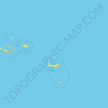
Name: Azores topographic map, elevation, terrain.

Location: Azores, Portugal (36.92763 -31.27563 39.72725 -24.77985)

Average elevation: 2 m

Minimum elevation: 0 m

Maximum elevation: 2,050 m

Other topographic maps

Click on a map to view its topography, its elevation and its terrain.

Lisbon

Portugal > Lisbon

Average elevation: 51 m

Lisbon

Portugal > Área Metropolitana de Lisboa > Lisbon

Average elevation: 110 m

Porto

Portugal > North > Porto

Average elevation: 85 m

Lisbon

Portugal > Lisbon

Average elevation: 51 m

Sintra

Portugal > Lisbon > Sintra

Average elevation: 175 m

Madeira

Portugal

The archipelago includes the islands of Madeira, Porto Santo, and the Desertas, administered together with the separate archipelago of the Savage Islands. Roughly half of the region's population lives in its capital, Funchal. The region has political and administrative autonomy through the Administrative…

Average elevation: 5 m

Algarve

Portugal

Average elevation: 99 m

Alfena

Portugal > Porto

Average elevation: 141 m

Carcavelos

Portugal > Lisbon > Cascais

Average elevation: 36 m

Alqueve

Portugal > Coimbra > Folques

Average elevation: 375 m

Coimbra

Portugal > Centro > Coimbra

Average elevation: 144 m

Vau

Portugal > Leiria > Óbidos

Average elevation: 34 m

Castro Verde

Portugal > Beja

The Castro Verde area is made up of extensive areas of rolling hills, geomorphological structures referred to as a peneplains, which vary in altitude from 300 to 900 ft (100–300 m.) above sea level. The area has planar relief, with a medium altitude of approximately 200 metres; the lowest point is about 110…

Average elevation: 206 m

Duas Igrejas

Portugal > Bragança

Average elevation: 737 m

São Miguel Island

Portugal

The highest elevation on São Miguel is the Pico da Vara at 1,103 metres (3,619 ft). Lying at the eastern end of the island, it is the focus of a Special Protection Area containing the largest remnant of laurisilva forest on the island, which is home to the endemic and critically endangered bird, the Azores…

Average elevation: 61 m

Agualva-Cacém

Portugal > Lisbon > Sintra

Average elevation: 96 m

Porto

Portugal > Porto

Average elevation: 77 m

Santiago do Cacém

Portugal > Setúbal

Average elevation: 87 m

Casal das Neras

Portugal > Coimbra > Soure > Figueiró do Campo

Average elevation: 40 m

Orjais

Portugal > Castelo Branco > Covilhã

Average elevation: 584 m

Casal dos Bernardos

Portugal > Santarém > Ourém

Average elevation: 222 m

Ponte da Barca

Portugal > Viana do Castelo

Average elevation: 362 m

Agrela

Portugal > Porto > Santo Tirso

Average elevation: 173 m

Olival

Portugal > Braga > Póvoa de Lanhoso > Geraz do Minho

Average elevation: 240 m

Marinha

Portugal > Leiria > Pedrógão Grande > Graça

Average elevation: 320 m

Portimão

Portugal > Faro

The geographical distribution of the altitude and relief of the municipality of Portimão generically follow the three types of territory present in the Barlavento: the coastal region, the Barrocal (a region between the coastal region and the mountains) and the mountains up north. Each one with their own…

Average elevation: 67 m

Condeixa-a-Nova

Portugal > Coimbra

Average elevation: 136 m

Senhora do Monte

Portugal > Lisbon > Arruda dos Vinhos

Average elevation: 122 m

Fornos de Maceira Dão

Portugal > Viseu > Mangualde

Average elevation: 409 m

Vila Real

Portugal

Average elevation: 619 m

Codecais

Portugal > Coimbra > Lousã > Serpins

Average elevation: 433 m

Longra

Portugal > Porto > Felgueiras

Average elevation: 270 m

Colorada

Portugal > Beja > Barrancos

Average elevation: 276 m

Tabuado

Portugal > Porto

Average elevation: 187 m

Barrosas (Santo Estêvão)

Portugal > Porto > Lousada

Average elevation: 430 m

Rio Mondego

Portugal

Average elevation: 427 m

Arouca

Portugal > Aveiro

Average elevation: 507 m

Gardunha

Portugal > Castelo Branco > São Vicente da Beira

Average elevation: 1,015 m

Lagoa

Portugal > Faro

Average elevation: 53 m

Cepões

Portugal > Viseu > Viseu

Average elevation: 569 m

Madeira Island

Portugal

Average elevation: 172 m

Barroca

Portugal > Castelo Branco > Fundão

Average elevation: 534 m

Almofala

Portugal > Viseu > Castro Daire

Average elevation: 899 m

Alqueva

Portugal > Évora > Amieira e Alqueva

Average elevation: 191 m

Setúbal

Portugal > Setúbal

Average elevation: 35 m

Castro Laboreiro

Portugal > Viana do Castelo > Melgaço

Average elevation: 931 m