
Las Cruces topographic map
Click on the map to display elevation.
Las Cruces
The approximate elevation of Las Cruces is 3,908 feet (1,191 m) above sea level.
About this map
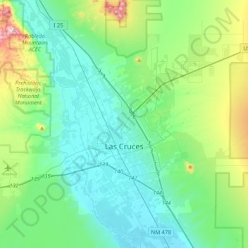
Name: Las Cruces topographic map, elevation, terrain.
Location: Las Cruces, Doña Ana County, New Mexico, United States (32.24229 -106.97329 32.43187 -106.66567)
Average elevation: 1,297 m
Minimum elevation: 1,174 m
Maximum elevation: 1,772 m
Other topographic maps
Click on a map to view its topography, its elevation and its terrain.
White Sands Missile Range
United States > New Mexico > Doña Ana County > White Sands
Average elevation: 1,306 m
White Sands Missile Range
United States > New Mexico > Doña Ana County > White Sands
Average elevation: 1,306 m