
Make a donation
Gear up for your next adventure:
As an Amazon Associate, this site earns from qualifying purchases at no extra cost to you.
Wilkes-Barre topographic map
Click on the map to display elevation.
Make a donation
Gear up for your next adventure:
As an Amazon Associate, this site earns from qualifying purchases at no extra cost to you.
Wilkes-Barre
According to the U.S. Census Bureau, the city has a total area of 7.2 square miles (19 km2), of which 6.8 square miles (18 km2) is land and 0.3 square miles (0.78 km2), or 4.60%, is water. The city is bordered by the Susquehanna River to the west. Most of Downtown is located on a wide floodplain. Floodwalls were constructed to protect a large percentage of the city. The elevation of the downtown area is about 550 feet (170 m) above sea level. As you travel inland, away from the river, the elevation rises. Wilkes-Barre Mountain is a physical barrier southeast of the city.
Make a donation
Gear up for your next adventure:
As an Amazon Associate, this site earns from qualifying purchases at no extra cost to you.
About this map
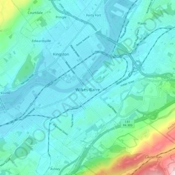
Name: Wilkes-Barre topographic map, elevation, terrain.
Location: Wilkes-Barre, Luzerne County, Pennsylvania, United States (41.22193 -75.92814 41.27292 -75.82685)
Average elevation: 218 m
Minimum elevation: 154 m
Maximum elevation: 574 m
Make a donation
Gear up for your next adventure:
As an Amazon Associate, this site earns from qualifying purchases at no extra cost to you.
Other topographic maps
Click on a map to view its topography, its elevation and its terrain.
Make a donation
Gear up for your next adventure:
As an Amazon Associate, this site earns from qualifying purchases at no extra cost to you.
Make a donation
Gear up for your next adventure:
As an Amazon Associate, this site earns from qualifying purchases at no extra cost to you.
Glen Summit
United States > Pennsylvania > Luzerne County > Fairview Township
Average elevation: 539 m
Roaring Brook
United States > Pennsylvania > Luzerne County > Hunlock Township
Average elevation: 337 m
Make a donation
Gear up for your next adventure:
As an Amazon Associate, this site earns from qualifying purchases at no extra cost to you.
Wapwallopen
United States > Pennsylvania > Luzerne County > Conyngham Township
Average elevation: 223 m
Town Hill
United States > Pennsylvania > Luzerne County > Huntington Township
Average elevation: 281 m
Make a donation
Gear up for your next adventure:
As an Amazon Associate, this site earns from qualifying purchases at no extra cost to you.
Huntington Mills
United States > Pennsylvania > Luzerne County > Huntington Township
Average elevation: 289 m
Make a donation
Gear up for your next adventure:
As an Amazon Associate, this site earns from qualifying purchases at no extra cost to you.
Make a donation
Gear up for your next adventure:
As an Amazon Associate, this site earns from qualifying purchases at no extra cost to you.
Liewellyn Corners
United States > Pennsylvania > Luzerne County > Bear Creek Township
Average elevation: 449 m
Hunlock Creek
United States > Pennsylvania > Luzerne County > Hunlock Township > Hunlock
Average elevation: 276 m
Make a donation
Gear up for your next adventure:
As an Amazon Associate, this site earns from qualifying purchases at no extra cost to you.
Wapwallopen
United States > Pennsylvania > Luzerne County > Conyngham Township
Average elevation: 223 m
Fern Glen
United States > Pennsylvania > Luzerne County > Black Creek Township
Average elevation: 391 m
Make a donation
Gear up for your next adventure:
As an Amazon Associate, this site earns from qualifying purchases at no extra cost to you.
South Pond Dam
United States > Pennsylvania > Luzerne County > Hanover Township
Average elevation: 204 m
Ricketts Glen State Park
United States > Pennsylvania > Luzerne County > Fairmount Township
The state's original plans for the new park included building an inn, an 18-hole golf course and country club, and a winter sports complex for skiing, ice boating, and tobogganing, as well as a beach with bathing facilities, cabins, and a tent camping area. Only the last three were actually built, all south of…
Average elevation: 588 m
Make a donation
Gear up for your next adventure:
As an Amazon Associate, this site earns from qualifying purchases at no extra cost to you.
Fern Glen
United States > Pennsylvania > Luzerne County > Black Creek Township
Average elevation: 391 m
Make a donation
Gear up for your next adventure:
As an Amazon Associate, this site earns from qualifying purchases at no extra cost to you.