
Drums topographic map
Interactive map
Click on the map to display elevation.
About this map
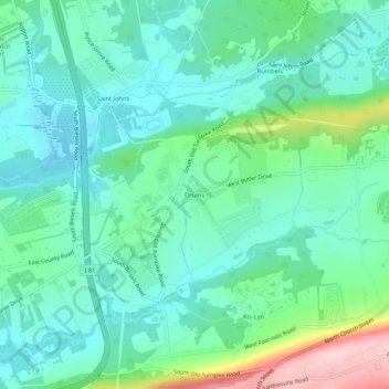
Name: Drums topographic map, elevation, terrain.
Location: Drums, Luzerne County, Pennsylvania, 18247, United States (40.99814 -76.01493 41.03814 -75.97493)
Average elevation: 340 m
Minimum elevation: 283 m
Maximum elevation: 517 m
Other topographic maps
Click on a map to view its topography, its elevation and its terrain.
Fern Glen
United States > Pennsylvania > Luzerne County > Black Creek Township
Fern Glen, Black Creek Township, Luzerne County, Pennsylvania, 18246, United States
Average elevation: 391 m
Wilkes-Barre
United States > Pennsylvania > Luzerne County
Wilkes-Barre, Luzerne County, Pennsylvania, United States
Average elevation: 217 m
Exeter
United States > Pennsylvania > Luzerne County
Exeter, Luzerne County, Pennsylvania, 18643, United States
Average elevation: 236 m
Dallas Township
United States > Pennsylvania > Luzerne County
Dallas Township, Luzerne County, Pennsylvania, United States
Average elevation: 387 m
Sugarloaf Township
United States > Pennsylvania > Luzerne County
Sugarloaf Township, Luzerne County, Pennsylvania, United States
Average elevation: 363 m
Franklin Township
United States > Pennsylvania > Luzerne County
Franklin Township, Luzerne County, Pennsylvania, United States
Average elevation: 364 m
Swoyersville
United States > Pennsylvania > Luzerne County
Swoyersville, Luzerne County, Pennsylvania, United States
Average elevation: 224 m
Plymouth
United States > Pennsylvania > Luzerne County
Plymouth, Luzerne County, Pennsylvania, 18651, United States
Average elevation: 185 m
South Pond Dam
United States > Pennsylvania > Luzerne County > Hanover Township
South Pond Dam, Hanover Township, Luzerne County, Pennsylvania, 18706, United States
Average elevation: 204 m
Hazleton
United States > Pennsylvania > Luzerne County
Hazleton, Luzerne County, Pennsylvania, 18201, United States
Average elevation: 510 m
Ricketts Glen State Park
United States > Pennsylvania > Luzerne County
Ricketts Glen State Park, Luzerne County, Pennsylvania, United States
Average elevation: 588 m
Dallas
United States > Pennsylvania > Luzerne County
Dallas, Luzerne County, Pennsylvania, 18612, United States
Average elevation: 364 m
Nanticoke
United States > Pennsylvania > Luzerne County
Nanticoke, Luzerne County, Pennsylvania, 18634, United States
Average elevation: 192 m
Plains Township
United States > Pennsylvania > Luzerne County
Plains Township, Luzerne County, Pennsylvania, 18711, United States
Average elevation: 352 m
Laurel Run
United States > Pennsylvania > Luzerne County
Laurel Run, Luzerne County, Pennsylvania, United States
Average elevation: 413 m
Mountain Top
United States > Pennsylvania > Luzerne County
Mountain Top, Luzerne County, Pennsylvania, United States
Average elevation: 371 m
Lehman
United States > Pennsylvania > Luzerne County > Lehman
Lehman, Luzerne County, Pennsylvania, 18654, United States
Average elevation: 382 m
Wyoming
United States > Pennsylvania > Luzerne County > Wyoming
Wyoming, Luzerne County, Pennsylvania, United States
Average elevation: 174 m
White Haven
United States > Pennsylvania > Luzerne County
White Haven, Luzerne County, Pennsylvania, United States
Average elevation: 391 m
Pringle
United States > Pennsylvania > Luzerne County
Pringle, Luzerne County, Pennsylvania, 18704, United States
Average elevation: 191 m
Glen Lyon
United States > Pennsylvania > Luzerne County > Newport Township
Glen Lyon, Newport Township, Luzerne County, Pennsylvania, 18617, United States
Average elevation: 266 m