Geolocate

Norway topographic map

Interactive map

Click on the map to display elevation.

Norway

Norway's topography is defined by its rugged and varied terrain, shaped by ancient geological processes and glacial activity. Dominating the landscape are the Scandinavian Mountains, which run through the country and include peaks like Galdhøpiggen, the highest in Northern Europe at 2,469 meters (8,100 feet). These mountains descend sharply to the west, forming the dramatic fjords for which Norway is renowned, such as the Sognefjord, the world's second deepest fjord. In contrast, the eastern regions feature more gradual slopes leading to expansive valleys and plateaus. The Hardangervidda plateau, for instance, is Europe's largest mountain plateau, characterized by its barren, treeless moorlands and numerous lakes. Glacial erosion has left a significant mark on the terrain, carving out deep valleys and leaving behind numerous glaciers, especially in the western part of the country. This diverse and dramatic landscape not only defines Norway's natural beauty but also influences its climate, biodiversity, and human activities.

About this map

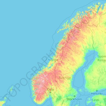
Name: Norway topographic map, elevation, terrain.

Location: Norway (57.75901 4.08753 71.38488 31.76159)

Average elevation: 143 m

Minimum elevation: -3 m

Maximum elevation: 2,267 m

Other topographic maps

Click on a map to view its topography, its elevation and its terrain.

Scandinavian Mountains

Norway > Innlandet

The mountain chain's highest summits are mostly concentrated in an area (of mean altitude of over 1,000 m) between Stavanger and Trondheim in South Norway, with numerous peaks over 1,300 m and some peaks over 2,000 m. Around Trondheim Fjord, peaks decrease in altitude to about 400–500 m rising again to…

Average elevation: 2,050 m

Lofoten

Norway > Nordland

Average elevation: 232 m

Oslo

Norway > Oslo

Average elevation: 186 m

Stavanger

Norway > Rogaland

The municipality of Stavanger is located in a coastal landscape, bordering the sea to the west and Boknafjorden in the northeast. The Byfjorden and Gandsfjorden run along the east side of the city. It is part of the Low-Jæren, a flat area of land consisting mostly of marsh, sand, and stone aur, that ranges…

Average elevation: 44 m

Trondheim

Norway > Trøndelag > Trondheim

Trondheim is situated where the River Nidelva meets Trondheim Fjord with an excellent harbour and sheltered condition. The river used to be deep enough for most boats in the Middle Ages. An avalanche of mud and stones made it less navigable and partly ruined the harbour in the mid-17th century. The…

Average elevation: 118 m

Aure

Norway > Møre og Romsdal

Average elevation: 64 m

Brandbu

Norway > Innlandet

Average elevation: 243 m

Nust

Norway > Innlandet

Average elevation: 194 m

Eid

Norway > Agder

Average elevation: 41 m

Gullberg

Norway > Vestland > Leirvik

Average elevation: 19 m

Valldal

Norway > Møre og Romsdal

Average elevation: 177 m

Sørkjul

Norway > Nordland

Average elevation: 28 m

Finse

Norway > Vestland

Average elevation: 1,331 m

Fosse

Norway > Vestland > Strandebarm

Average elevation: 146 m

Torskmannen

Norway > Nordland

Average elevation: 370 m

Djupvåg

Norway > Troms

Average elevation: 102 m

Knivsøya

Norway > Østfold > Isebakke

Average elevation: 34 m

Stura

Norway > Vestland

Average elevation: 10 m

Evenstad

Norway > Innlandet

Average elevation: 358 m

Uthaug

Norway > Trøndelag

Average elevation: 3 m

Mo i Rana

Norway > Nordland

Average elevation: 178 m

Andabeløy

Norway > Agder

Average elevation: 37 m

Bryne

Norway > Rogaland

Average elevation: 38 m

Kodal

Norway > Vestfold

An ancient hill fort can be seen about 5 kilometres (3.1 mi) from the village centre of Kodal, connected by a hiking trail from the village centre. A closer parking lot can be found at Kodalveien 414. The trail is marked by blue paint on trees and rocks, and a variety of interpretive signs describing the fauna…

Average elevation: 75 m

Geirangerfjord

Norway > Møre og Romsdal > Geiranger

Average elevation: 812 m

Haakonsvern

Norway > Vestland > Bergen

Average elevation: 26 m

Dunderlandsdalen

Norway > Nordland

Average elevation: 644 m

Storvik

Norway > Nordland

Average elevation: 254 m

Rauland

Norway > Telemark

Average elevation: 761 m

Notodden

Norway > Telemark

Average elevation: 216 m

Eggedal

Norway > Buskerud

Average elevation: 482 m

Ålen

Norway > Trøndelag

Average elevation: 539 m

Bruflat

Norway > Innlandet

Average elevation: 512 m

Oppeid

Norway > Nordland

Average elevation: 42 m

Kolbu

Norway > Innlandet

Average elevation: 315 m

Rødberg

Norway > Troms > Tromsø

Average elevation: 244 m

Skien

Norway > Telemark

Average elevation: 176 m

Spilling

Norway > Agder

Average elevation: 173 m

Skrim

Norway > Buskerud

Average elevation: 621 m

Leknes

Norway > Nordland

Average elevation: 60 m

Narvik

Norway > Nordland

Average elevation: 169 m

Skjold

Norway > Rogaland

Average elevation: 74 m

Augedal

Norway > Innlandet > Brandbu

Average elevation: 235 m

Galdhøpiggen

Norway > Innlandet

At Juvasshytta there is an alpine ski resort with lift on a glacier, reaching an elevation of 2,200 metres (7,200 ft) above sea level, the highest in Scandinavia. It is called Galdhøpiggen Summer Ski Centre and is open from June and all the summer when the road is open.

Average elevation: 2,105 m

Narvik

Norway > Nordland

Average elevation: 169 m

Geirangerfjord

Norway > Møre og Romsdal > Geiranger

Average elevation: 812 m

Klokkarvik

Norway > Vestland

Average elevation: 36 m

Midtfjellet

Norway > Møre og Romsdal

Average elevation: 162 m

Beerenberg

Norway > Jan Mayen

Average elevation: 1,762 m

Hornelen

Norway > Vestland

The horizontal distance from the summit to the sea is approximately 500 metres (1,600 ft). Approximately 1 kilometre (0.62 mi) to the west of the cliffside is the highest point on the island Bremangerlandet, called Svartevassegga which has an elevation of 889 metres (2,917 ft). The rock in Hornelen consists of…

Average elevation: 282 m

Henningsvær

Norway > Nordland

Average elevation: 2 m

Glittertinden

Norway > Innlandet

The mountain reaches an elevation of 2,452 metres (8,045 ft) without the glacier on top of its peak. As of 2008 it reached 2,465 metres (8,087 ft) above sea level including the glacier, measured as summer minimum. But in August 2022, the mountain was seen basically without the glacier.

Average elevation: 2,135 m

Granåsen

Norway > Buskerud

Average elevation: 609 m

To

Norway > Vestland > Uggdalseidet

Average elevation: 108 m

Lindesnes fyr

Norway > Agder

Lindesnes Lighthouse (Norwegian: Lindesnes fyr) is a coastal lighthouse at the southernmost tip of Norway, about 10 kilometres (6.2 mi) southwest of the village of Høllen in Lindesnes municipality in Agder county. The present lighthouse was built in 1915, although the station was first built in 1656 to mark…

Average elevation: 10 m

Haver

Norway > Rogaland > Sirevåg

Average elevation: 7 m

Femundsenden

Norway > Innlandet

Average elevation: 676 m

Rindi

Norway > Agder

Average elevation: 854 m

Austbygde

Norway > Telemark

Average elevation: 426 m

Norefjell

Norway > Buskerud

Average elevation: 758 m

Egersund

Norway > Rogaland

Average elevation: 68 m

Narvik

Norway > Nordland

Average elevation: 169 m

Vikersund

Norway > Buskerud

Average elevation: 217 m

Bardufoss

Norway > Troms

Average elevation: 170 m

Svalbard

Norway

Average elevation: 169 m

Moelv

Norway > Innlandet

Average elevation: 232 m

Eiksund

Norway > Møre og Romsdal

Average elevation: 112 m

Lom

Norway > Innlandet

Average elevation: 600 m

Austbø

Norway > Nordland

Average elevation: 1 m

Øvre Årdal

Norway > Vestland

Average elevation: 378 m

Vardø

Norway > Finnmark

Average elevation: 10 m

Skåbu

Norway > Innlandet

Average elevation: 845 m

Hemnesberget

Norway > Nordland

Average elevation: 21 m

Brynna

Norway > Trøndelag > Høylandet

Average elevation: 100 m

Vinje

Norway > Vestland

Average elevation: 454 m

Sandane

Norway > Telemark

Average elevation: 625 m

Sandshamn

Norway > Møre og Romsdal

Average elevation: 21 m

Per Olso-skjæret

Norway > Nordland

Average elevation: 4 m

Håkvik - Ginnasluokta

Norway > Nordland

Average elevation: 94 m

Mjølfjell

Norway > Vestland

Average elevation: 1,197 m

Valderhaug

Norway > Møre og Romsdal

Average elevation: 11 m

Tønsberg

Norway > Vestfold

Average elevation: 38 m

Leon

Norway > Østfold

Average elevation: 134 m

Hålandsosen

Norway > Rogaland

Average elevation: 198 m

Lægdafossen

Norway > Vestland

Average elevation: 430 m

Dalsnibba

Norway > Møre og Romsdal

Average elevation: 1,111 m

Haukeliseter

Norway > Telemark

Average elevation: 1,057 m

Gaustatoppen

Norway > Telemark

Average elevation: 1,360 m

Midle

Norway > Rogaland > Sandnes

Average elevation: 16 m

Knapstad

Norway > Østfold

Average elevation: 128 m

Been

Norway > Vestland > Utvær

Average elevation: 0 m

Vagle

Norway > Rogaland

Average elevation: 50 m

Lørenfallet

Norway > Akershus

Average elevation: 133 m

Rjupa

Norway > Agder

Average elevation: 893 m

Hovden

Norway > Vestland

Average elevation: 1,040 m

Fauske - Fuossko

Norway > Nordland

Average elevation: 98 m

Bersagel

Norway > Rogaland

Average elevation: 67 m

Moss

Norway > Østfold

Average elevation: 42 m

Randaberg

Norway > Rogaland

Average elevation: 10 m