
Make a donation
Gear up for your next adventure:
As an Amazon Associate, this site earns from qualifying purchases at no extra cost to you.
Scandinavian Mountains topographic map
Click on the map to display elevation.
Make a donation
Gear up for your next adventure:
As an Amazon Associate, this site earns from qualifying purchases at no extra cost to you.
Scandinavian Mountains
The mountain chain's highest summits are mostly concentrated in an area (of mean altitude of over 1,000 m) between Stavanger and Trondheim in South Norway, with numerous peaks over 1,300 m and some peaks over 2,000 m. Around Trondheim Fjord, peaks decrease in altitude to about 400–500 m rising again to heights in excess of 1,900 m further north in Swedish Lapland and nearby areas of Norway. The southern part of the mountain range contains the highest mountain of Northern Europe, Galdhøpiggen at almost 2,500 m. This part of the mountain chain is also broader and contains a series of plateaux and gently undulating surfaces that hosts scattered inselbergs. The plateaux and undulating surfaces of the southern Scandinavian Mountains form a series of stepped surfaces. Geomorphologist Karna Lidmar-Bergström and co-workers recognize five widespread stepped surfaces. In eastern Norway, some of the stepped surfaces merge into a single surface. Dovre and Jotunheimen are rises from the highest of the stepped surfaces. In south-western Norway, the plateaux and gently undulating surfaces are strongly dissected by fjords and valleys. The mountain chain is present in Sweden from northern Dalarna northwards; south of this point the Scandinavian Mountains lie completely within Norway. Most of the Scandinavian Mountains lack "alpine topography", and where present it does not relate to altitude. An example of this is the distribution of cirques in southern Norway that can be found both near sea level and at 2,000 m. Most cirques are found between 1,000 and 1,500 m.
Make a donation
Gear up for your next adventure:
As an Amazon Associate, this site earns from qualifying purchases at no extra cost to you.
About this map
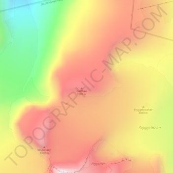
Name: Scandinavian Mountains topographic map, elevation, terrain.
Location: Scandinavian Mountains, Lom, Innlandet, Norway (61.64995 8.31995 61.65005 8.32005)
Average elevation: 2,050 m
Minimum elevation: 1,484 m
Maximum elevation: 2,467 m
Make a donation
Gear up for your next adventure:
As an Amazon Associate, this site earns from qualifying purchases at no extra cost to you.
Other topographic maps
Click on a map to view its topography, its elevation and its terrain.
Dovre
The Dovre area is in a valley at fairly high altitude and isolated from the sea by mountain ranges, giving some rain shadow effect for Dovre. Dovre, with the town Dombås, has a subarctic climate (Dfc) with sparse precipitation. The driest season is late winter and spring, and the wettest season is summer.…
Average elevation: 1,195 m
Make a donation
Gear up for your next adventure:
As an Amazon Associate, this site earns from qualifying purchases at no extra cost to you.
Make a donation
Gear up for your next adventure:
As an Amazon Associate, this site earns from qualifying purchases at no extra cost to you.
Make a donation
Gear up for your next adventure:
As an Amazon Associate, this site earns from qualifying purchases at no extra cost to you.
Make a donation
Gear up for your next adventure:
As an Amazon Associate, this site earns from qualifying purchases at no extra cost to you.
Hamar
Hamar has a humid continental climate (Dfb) with fairly dry and cold winters, and comfortably warm summers. The Hamar II weather station, at an elevation of 141 metres (463 ft), started recording in 1968. The all-time high 33 °C (91 °F) was recorded in July 2018, which was the warmest month on record with…
Average elevation: 445 m
Make a donation
Gear up for your next adventure:
As an Amazon Associate, this site earns from qualifying purchases at no extra cost to you.
Make a donation
Gear up for your next adventure:
As an Amazon Associate, this site earns from qualifying purchases at no extra cost to you.
Make a donation
Gear up for your next adventure:
As an Amazon Associate, this site earns from qualifying purchases at no extra cost to you.
Make a donation
Gear up for your next adventure:
As an Amazon Associate, this site earns from qualifying purchases at no extra cost to you.
Dovre
The Dovre area is in a valley at fairly high altitude and isolated from the sea by mountain ranges, giving some rain shadow effect for Dovre. Dovre, with the town Dombås, has a subarctic climate (Dfc) with sparse precipitation. The driest season is late winter and spring, and the wettest season is summer.…
Average elevation: 1,195 m
Make a donation
Gear up for your next adventure:
As an Amazon Associate, this site earns from qualifying purchases at no extra cost to you.
Make a donation
Gear up for your next adventure:
As an Amazon Associate, this site earns from qualifying purchases at no extra cost to you.
Make a donation
Gear up for your next adventure:
As an Amazon Associate, this site earns from qualifying purchases at no extra cost to you.
Hamar
Hamar has a humid continental climate (Dfb) with fairly dry and cold winters, and comfortably warm summers. The Hamar II weather station, at an elevation of 141 metres (463 ft), started recording in 1968. The all-time high 33 °C (91 °F) was recorded in July 2018, which was the warmest month on record with…
Average elevation: 445 m
Make a donation
Gear up for your next adventure:
As an Amazon Associate, this site earns from qualifying purchases at no extra cost to you.
Make a donation
Gear up for your next adventure:
As an Amazon Associate, this site earns from qualifying purchases at no extra cost to you.
Make a donation
Gear up for your next adventure:
As an Amazon Associate, this site earns from qualifying purchases at no extra cost to you.
Make a donation
Gear up for your next adventure:
As an Amazon Associate, this site earns from qualifying purchases at no extra cost to you.