
Tingnes topographic map
Interactive map
Click on the map to display elevation.
About this map
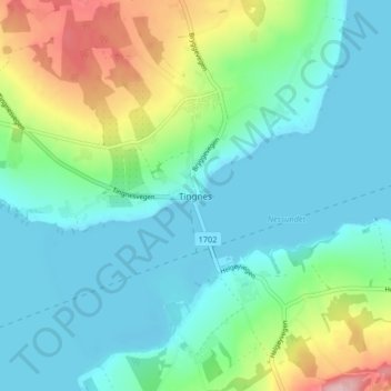
Name: Tingnes topographic map, elevation, terrain.
Location: Tingnes, Ringsaker, Innlandet, 2350, Norway (60.74230 10.92164 60.78230 10.96164)
Average elevation: 166 m
Minimum elevation: 120 m
Maximum elevation: 303 m
Other topographic maps
Click on a map to view its topography, its elevation and its terrain.
Dovre
The Dovre area is in a valley at fairly high altitude and isolated from the sea by mountain ranges, giving some rain shadow effect for Dovre. Dovre, with the town Dombås, has a subarctic climate (Dfc) with sparse precipitation. The driest season is late winter and spring, and the wettest season is summer.…
Average elevation: 1,195 m