
Galdhøpiggen topographic map
Interactive map
Click on the map to display elevation.
About this map
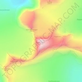
Name: Galdhøpiggen topographic map, elevation, terrain.
Location: Galdhøpiggen, Lom, Innlandet, Norway (61.63642 8.31239 61.63652 8.31249)
Average elevation: 2,105 m
Minimum elevation: 1,791 m
Maximum elevation: 2,467 m
At Juvasshytta there is an alpine ski resort with lift on a glacier, reaching an elevation of 2,200 metres (7,200 ft) above sea level, the highest in Scandinavia. It is called Galdhøpiggen Summer Ski Centre and is open from June and all the summer when the road is open.
Other topographic maps
Click on a map to view its topography, its elevation and its terrain.
Li
Norway > Innlandet > Skammestein
Li, Skammestein, Øystre Slidre, Innlandet, 2950, Norway
Average elevation: 774 m
Scandinavian Mountains
Scandinavian Mountains, Lom, Innlandet, Norway
Average elevation: 2,050 m
Fregn naturreservat
Fregn naturreservat, Trysil, Innlandet, Norway
Average elevation: 673 m
Viewpoint Snøhetta
Viewpoint Snøhetta, Vålåsjøhøvegen, Dovre, Innlandet, 2661, Norway
Average elevation: 1,157 m
Beitostølen
Beitostølen, Øystre Slidre, Innlandet, 2953, Norway
Average elevation: 914 m