
Fort Cumberland topographic map
Interactive map
Click on the map to display elevation.
About this map
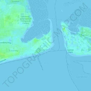
Name: Fort Cumberland topographic map, elevation, terrain.
Average elevation: 1 m
Minimum elevation: -2 m
Maximum elevation: 9 m
Other topographic maps
Click on a map to view its topography, its elevation and its terrain.
Tipner
United Kingdom > England > Portsmouth
Tipner, Portsmouth, England, PO2 8RD, United Kingdom
Average elevation: 3 m
Portsea Island
United Kingdom > England > Portsmouth
Portsea Island, Portsmouth, England, United Kingdom
Average elevation: 3 m
Portsdown Hill
United Kingdom > England > Portsmouth
Portsdown Hill, Portsdown Hill Road, Wymering, Cosham, Portsmouth, South East, England, PO6 3LS, United Kingdom
Average elevation: 39 m
Bastion 3, Hilsea Lines
United Kingdom > England > Portsmouth
Bastion 3, Hilsea Lines, Scott Road, Hilsea, Portsmouth, England, PO3 5LX, United Kingdom
Average elevation: 4 m
Gobs Barrow
United Kingdom > England > Portsmouth
Gobs Barrow, Portsdown Hill Road, Drayton, Portsmouth, South East England, England, PO6 1BG, United Kingdom
Average elevation: 40 m
Hilsea Lines
United Kingdom > England > Portsmouth > Tipner
Hilsea Lines, Hilsea Crescent, Hilsea, Tipner, Portsmouth, South East, England, PO2 9SN, United Kingdom
Average elevation: 5 m
Victoria Park
United Kingdom > England > Portsmouth
Victoria Park, Stamshaw, Portsea, Portsmouth, South East, England, PO1 3HJ, United Kingdom
Average elevation: 4 m