
Nyarugenge District topographic map
Interactive map
Click on the map to display elevation.
About this map
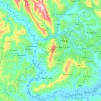
Name: Nyarugenge District topographic map, elevation, terrain.
Location: Nyarugenge District, Kigali City, Rwanda (-2.07588 29.97953 -1.86686 30.08506)
Average elevation: 1,486 m
Minimum elevation: 1,336 m
Maximum elevation: 2,069 m
Other topographic maps
Click on a map to view its topography, its elevation and its terrain.
Kigali
Rwanda > Kigali City > Nyarugenge District
Kigali is located in the centre of Rwanda, at 1°57′S 30°4′E. Like the rest of Rwanda it uses Central Africa Time, and is two hours ahead of Coordinated Universal Time (UTC+02:00) throughout the year. The city is coterminous with the province of Kigali, one of the five provinces of Rwanda introduced in…
Average elevation: 1,530 m