
Make a donation
Gear up for your next adventure:
As an Amazon Associate, this site earns from qualifying purchases at no extra cost to you.
High Peak topographic map
Click on the map to display elevation.
Make a donation
Gear up for your next adventure:
As an Amazon Associate, this site earns from qualifying purchases at no extra cost to you.
About this map
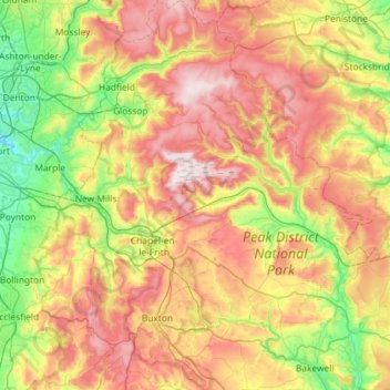
Name: High Peak topographic map, elevation, terrain.
Location: High Peak, Derbyshire, East Midlands, England, United Kingdom (53.19468 -2.03410 53.54045 -1.65382)
Average elevation: 303 m
Minimum elevation: 49 m
Maximum elevation: 637 m
Derbyshire trails, hiking, mountain biking, running and outdoor activities
Make a donation
Gear up for your next adventure:
As an Amazon Associate, this site earns from qualifying purchases at no extra cost to you.
Other topographic maps
Click on a map to view its topography, its elevation and its terrain.
Make a donation
Gear up for your next adventure:
As an Amazon Associate, this site earns from qualifying purchases at no extra cost to you.
Make a donation
Gear up for your next adventure:
As an Amazon Associate, this site earns from qualifying purchases at no extra cost to you.
Make a donation
Gear up for your next adventure:
As an Amazon Associate, this site earns from qualifying purchases at no extra cost to you.
Make a donation
Gear up for your next adventure:
As an Amazon Associate, this site earns from qualifying purchases at no extra cost to you.
Make a donation
Gear up for your next adventure:
As an Amazon Associate, this site earns from qualifying purchases at no extra cost to you.
Bolehill
United Kingdom > England > Derbyshire > Derbyshire Dales > Wirksworth CP
Average elevation: 220 m
Black Rocks
United Kingdom > England > Derbyshire > Derbyshire Dales > Cromford CP
Average elevation: 199 m
Make a donation
Gear up for your next adventure:
As an Amazon Associate, this site earns from qualifying purchases at no extra cost to you.
Kinder Scout
United Kingdom > England > Derbyshire > High Peak
Kinder Scout is part of the Dark Peak Site of Special Scientific Interest, and part of the plateau was designated as a National Nature Reserve in 2009. Much of the area is owned and managed by the National Trust as part of its High Peak Estate. The city of Manchester and the Greater Manchester conurbation can…
Average elevation: 555 m
Make a donation
Gear up for your next adventure:
As an Amazon Associate, this site earns from qualifying purchases at no extra cost to you.
Plaistow Green
United Kingdom > England > Derbyshire > Amber Valley > Crich CP
Average elevation: 180 m
Make a donation
Gear up for your next adventure:
As an Amazon Associate, this site earns from qualifying purchases at no extra cost to you.
Mercia Marina
United Kingdom > England > Derbyshire > South Derbyshire > Willington CP
Average elevation: 51 m
Grassmoor Country Park
United Kingdom > England > Derbyshire > North East Derbyshire > Corbriggs
Average elevation: 116 m
Make a donation
Gear up for your next adventure:
As an Amazon Associate, this site earns from qualifying purchases at no extra cost to you.
Padley Gorge
United Kingdom > England > Derbyshire > Derbyshire Dales > Grindleford
Average elevation: 316 m
Make a donation
Gear up for your next adventure:
As an Amazon Associate, this site earns from qualifying purchases at no extra cost to you.
Make a donation
Gear up for your next adventure:
As an Amazon Associate, this site earns from qualifying purchases at no extra cost to you.
Alfreton Park
United Kingdom > England > Derbyshire > Amber Valley > Alfreton CP > Oakerthorpe
Average elevation: 116 m
Highlane
United Kingdom > England > Derbyshire > North East Derbyshire > Eckington > Ridgeway
Average elevation: 130 m
Rother Valley Country Park
United Kingdom > England > Derbyshire > Rotherham > Swallownest
Average elevation: 62 m
Stanage Plantation
United Kingdom > England > Derbyshire > Derbyshire Dales > Hathersage
Average elevation: 360 m
Make a donation
Gear up for your next adventure:
As an Amazon Associate, this site earns from qualifying purchases at no extra cost to you.
Upper Holloway
United Kingdom > England > Derbyshire > Amber Valley > Holloway
Average elevation: 189 m
Derwent
United Kingdom > England > Derbyshire > High Peak > Bamford > Yorkshire Bridge
Average elevation: 293 m
Make a donation
Gear up for your next adventure:
As an Amazon Associate, this site earns from qualifying purchases at no extra cost to you.
Staunton Harold Reservoir
United Kingdom > England > Derbyshire > South Derbyshire > Melbourne CP
Average elevation: 93 m
Make a donation
Gear up for your next adventure:
As an Amazon Associate, this site earns from qualifying purchases at no extra cost to you.
Make a donation
Gear up for your next adventure:
As an Amazon Associate, this site earns from qualifying purchases at no extra cost to you.
Norwood Cottage Lakes
United Kingdom > England > Derbyshire > North East Derbyshire > Killamarsh
Average elevation: 93 m
Holestone Moor
United Kingdom > England > Derbyshire > North East Derbyshire > Ashover CP
Average elevation: 231 m
Make a donation
Gear up for your next adventure:
As an Amazon Associate, this site earns from qualifying purchases at no extra cost to you.
Crowden Great Brook
United Kingdom > England > Derbyshire > High Peak > Tintwistle
Average elevation: 459 m
Wirksworth Moor
United Kingdom > England > Derbyshire > Derbyshire Dales > Wirksworth CP
Average elevation: 207 m
Make a donation
Gear up for your next adventure:
As an Amazon Associate, this site earns from qualifying purchases at no extra cost to you.
Lightwood
United Kingdom > England > Derbyshire > North East Derbyshire > Eckington
Average elevation: 168 m
Kinder Scout
United Kingdom > England > Derbyshire > High Peak
Kinder Scout is part of the Dark Peak Site of Special Scientific Interest, and part of the plateau was designated as a National Nature Reserve in 2009. Much of the area is owned and managed by the National Trust as part of its High Peak Estate. The city of Manchester and the Greater Manchester conurbation can…
Average elevation: 555 m
Make a donation
Gear up for your next adventure:
As an Amazon Associate, this site earns from qualifying purchases at no extra cost to you.
Hathersage Booths
United Kingdom > England > Derbyshire > Derbyshire Dales > Hathersage
Average elevation: 260 m
Make a donation
Gear up for your next adventure:
As an Amazon Associate, this site earns from qualifying purchases at no extra cost to you.
Make a donation
Gear up for your next adventure:
As an Amazon Associate, this site earns from qualifying purchases at no extra cost to you.
Make a donation
Gear up for your next adventure:
As an Amazon Associate, this site earns from qualifying purchases at no extra cost to you.
Make a donation
Gear up for your next adventure:
As an Amazon Associate, this site earns from qualifying purchases at no extra cost to you.
Bleaklow Head
United Kingdom > England > Derbyshire > High Peak
Much of the main plateau of Bleaklow is a boggy peat moorland, seamed by 'groughs' (pronounced 'gruffs', water-eroded channels in the peat) and lacking strong changes in elevation – in poor conditions its traverse is probably the most navigationally challenging in the Peak District.
Average elevation: 577 m
Make a donation
Gear up for your next adventure:
As an Amazon Associate, this site earns from qualifying purchases at no extra cost to you.
Denby Bottles
United Kingdom > England > Derbyshire > Amber Valley > Denby CP
Average elevation: 108 m
Make a donation
Gear up for your next adventure:
As an Amazon Associate, this site earns from qualifying purchases at no extra cost to you.
Derwent
United Kingdom > England > Derbyshire > High Peak > Bamford > Yorkshire Bridge
Average elevation: 287 m
Slaley
United Kingdom > England > Derbyshire > Derbyshire Dales > Matlock > Bonsall CP
Average elevation: 263 m
Make a donation
Gear up for your next adventure:
As an Amazon Associate, this site earns from qualifying purchases at no extra cost to you.