
River Dart topographic map
Interactive map
Click on the map to display elevation.
About this map
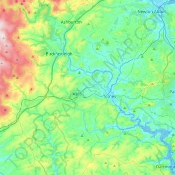
Name: River Dart topographic map, elevation, terrain.
Average elevation: 121 m
Minimum elevation: -4 m
Maximum elevation: 493 m
Devon trails, hiking, mountain biking, running and outdoor activities
Other topographic maps
Click on a map to view its topography, its elevation and its terrain.
Plymouth
United Kingdom > England > Devon > Plymouth
The River Plym, which flows off Dartmoor to the north-east, forms a smaller estuary to the east of the city called Cattewater. Plymouth Sound is protected from the sea by the Plymouth Breakwater, in use since 1814. In the Sound is Drake's Island which is seen from Plymouth Hoe, a flat public area on top of…
Average elevation: 81 m
Southbrook
United Kingdom > England > Devon > Teignbridge > Buckland in the Moor
Average elevation: 239 m
Burrator Reservoir
United Kingdom > England > Devon > West Devon > Meavy > Sheepstor
Average elevation: 255 m
Ponsworthy
United Kingdom > England > Devon > Teignbridge > Widecombe in the Moor
Average elevation: 278 m